Sunday, November 18, 2018

16. Muslim shrines in Lod

In 1930s there were two mosques and 14 Muslim shrines in Arabic city Ludd (Hebrew: Lod). Now both mosques continue to function, but 5 out of 14 shrines survived.

Arabic city Ludd. Photo of 1932


Mashhad sheikh ‘Abd ar-Rahman ibn ‘Awf
مشهد الشيخ عبد الرحمن بن عوف
קבר שייח' עבד אל-רחמן בן עוף

‘Abd ar-Rahman ibn ‘Awf was one of the companions (ashabs) of Muhammad the Prophet. According to the tradition, he died in Medina and was buried in al-Baqi‘ cemetery. But the Muslims who lived in Palestine believed that Ibn ‘Awf was buried on their land, and they even built a mashhad (a shrine) in his honor to the east from the city of Ludd. An Arabic explorer Mudjir ad-Din mentioned this shrine (1496): “Near Ludd from the eastern side there is a mashhad, the the tomb of Abu Muhammad ‘Abd ar-Rahman ibn ‘Aouf, the companion [of Muhammad], a supporter who died in 32 of Hegira” (Sauvaire 1876, 211).

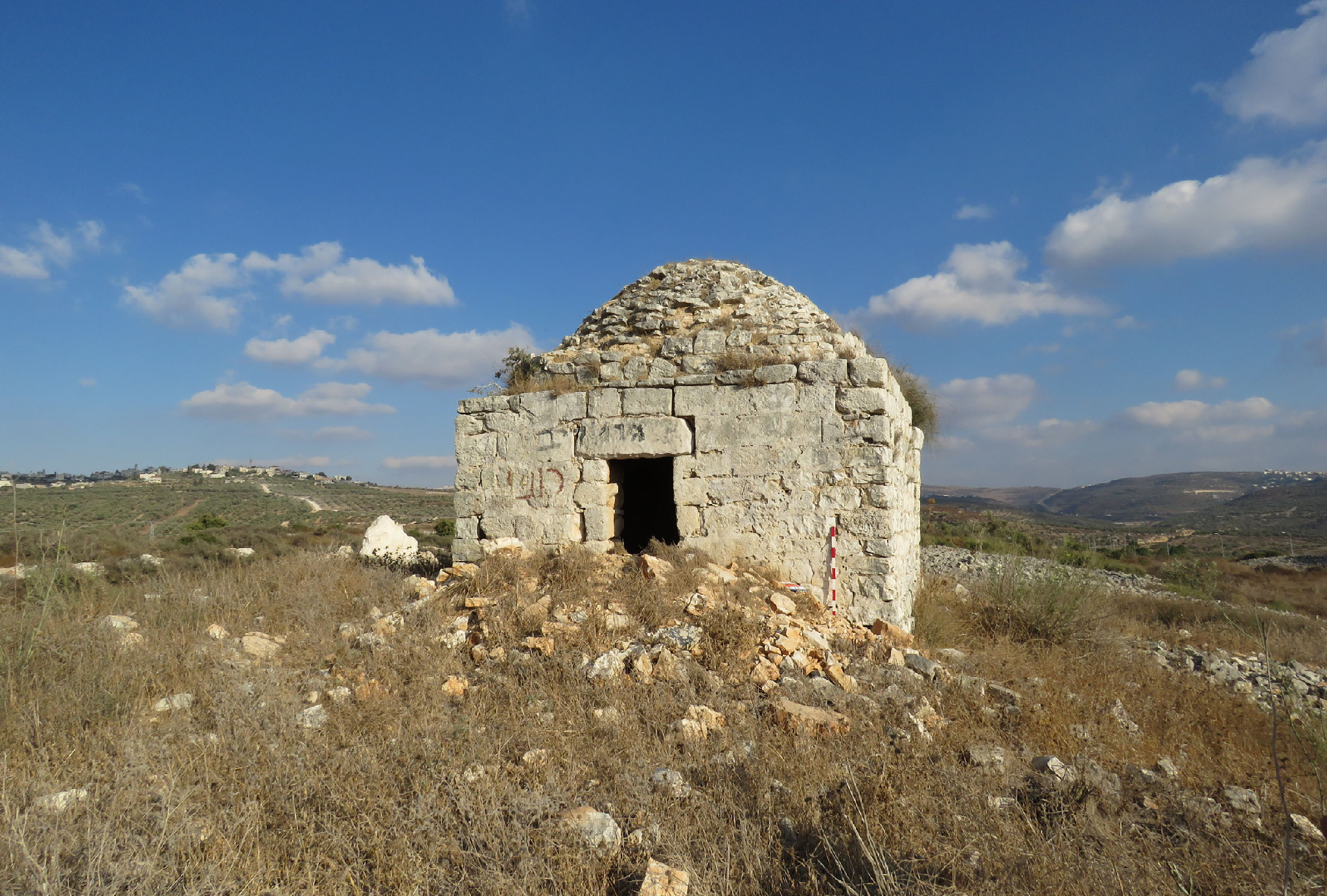
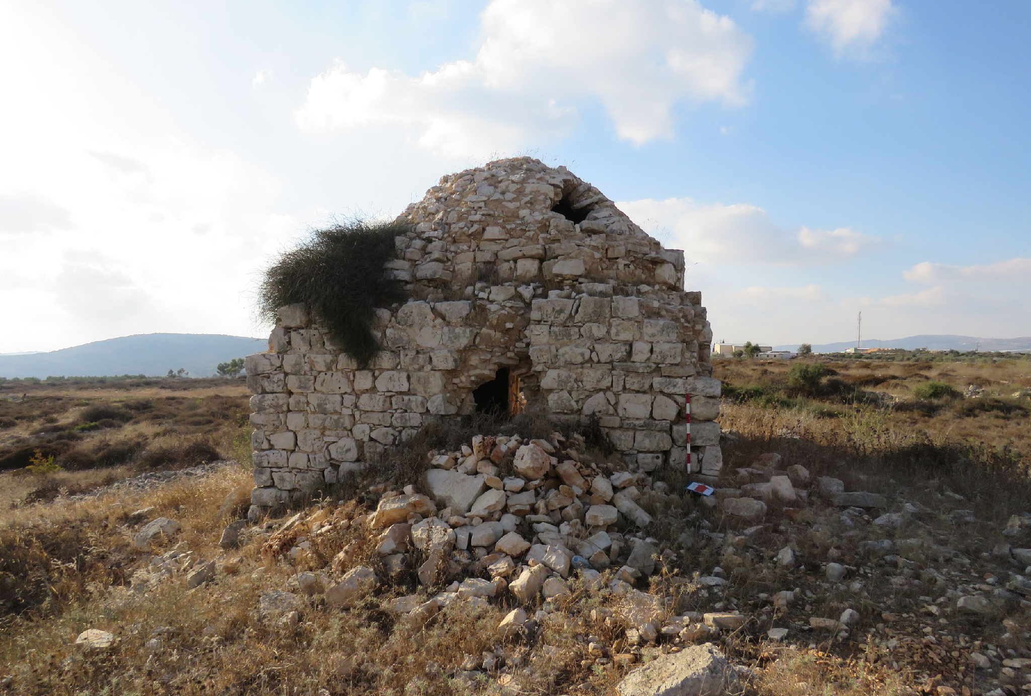
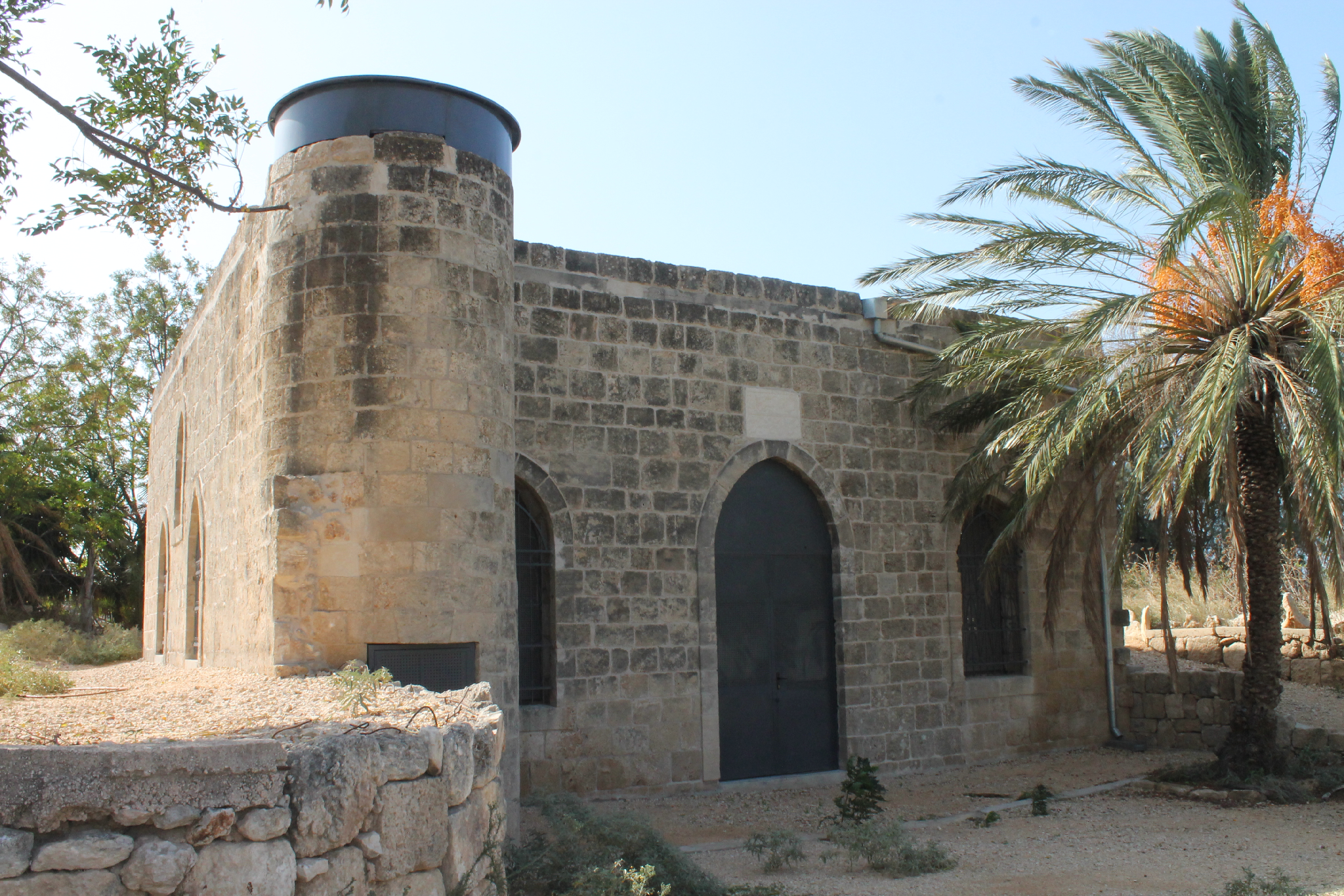
Now the mashhad  Ibn ‘Awf is on the territory of an old Muslim cemetery. Almost nothing left from the Mamluk's building. A modern Prayer house is built on its basement, and only a green dome of the survived shrine marks the place where the cenotaph of Ibn ‘Awf is.


Route. This Muslim shrine is located in the eastern part of Lod, at the entrance to the city by Route 443 or via street ha-Hashmonaim.

Visited: 12.08.15
Coordinates: 31°57'16.4"N 34°54'18.2"E
Location of the object on Google Maps


Maqam sheikh Ibrahim as-Suwayq
مقام الشيخ ابراهيم
קבר שייח' איברהים

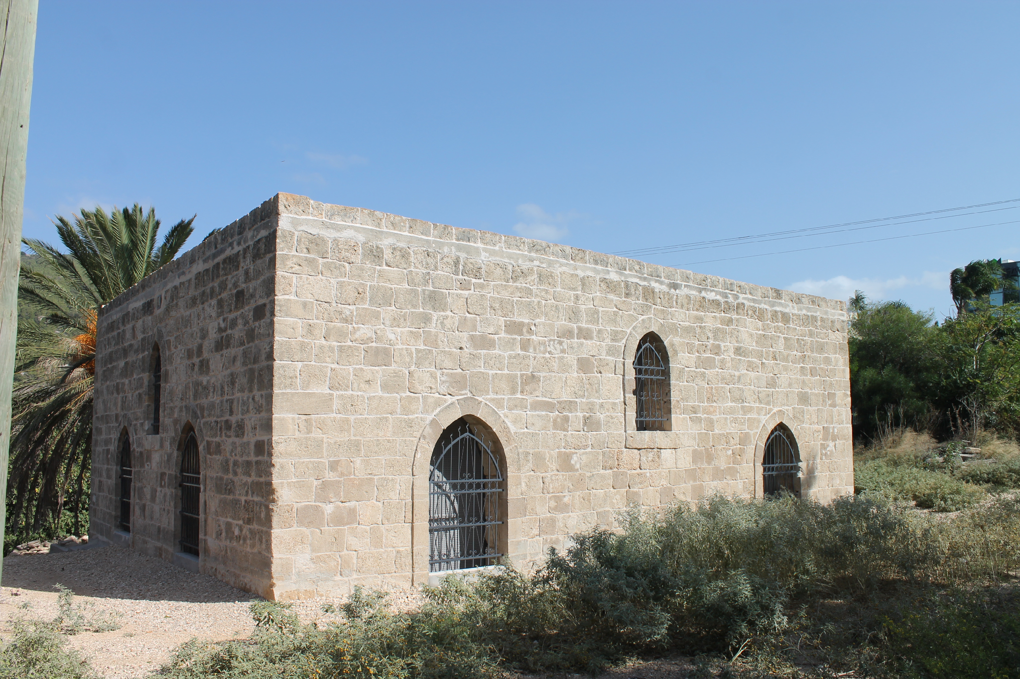
In the center of Lod, on Hashmonaim street (Route 443) there is an old Muslim cemetery; very untidy and neglected, despite the fact that it is under protection. Near the entrance to the cemetery stands Maqam sheikh Ibrahim nearly all covered with ivy. Only the north wall with a wide arch doesn’t have ivy on it. A. Petersen visited the maqam in 1994 and described it so: “The maqam consists of a rectangular cross-vaulted structure (4m x 4m) with a small dome in the top. The east face is open and there are windows in the north and south sides. The outlines of a grave or cenotaph can be seen outlined on the floor. An inscription dated to 1119 H. (1706–1707 CE) on the exterior of the building states that this is the tomb of Shaykh Ibrahim Suwayq” (2001, 209).

The old Muslim cemetery of Lod


Photo of 1994 (from the book by A. Petersen)
The exact dimensions of the structure are 4.66 x 4.50m. The entrance to the maqam is not on the east, but on the north-east side, where a wide arch is present. There is an inscription in Arabic on the north wall, however, to the right of the entrance. Dome of the maqam, apparently, completely covered with ivy. Note also that the tomb has no mihrab. Not so long ago the maqam was whitewashed and its floors were tiled. A modern tombstone with an inscription in Arabic “Muhammad al-Mabtuli” was installed instead of the cenotaph. Note that the Mosque of sheikh Ibrahim al-Matbuli (d. 1472), known even to researchers of the 19th century (Palmer 1881, 273; Stewardson 1888, 139), is located on the Tel Ashdod.

Wednesday, November 14, 2018

14c. Abandoned Mosques. Golan Heights


Mosque in Kafr ‘Aqab
مسجد في كفر عقاب
מסגד בכפר עקיב

According to the photos made just after the Six-Days War in 1967, the mosque in Kafr ‘Aqab stood in the middle of the village. Now there is only a basement of the mosque and 1–1.5 m high walls on the hill. Almost nothing left from the minaret.

Photo of 1968

View from the south

View from the south-west

Route. On 20th km turn from Highway 92 to moshav Ramot and in 250 m to the left there is a hill with the ruins of Kafr ‘Aqab village.

Visited: 21.08.15
Coordinates: 32°51'46.4"N 35°39'16.1"E
Location of the object on Google Maps


Mosque in Khushniya
مسجد في الخشنية
מסגד בחושניה

This mosque is observable for all who take Highway 87 and pass a former Syrian (Cherkess) village Khushniya, as the mosque stands right near the road. It was built just before the Six-Days War and now is the only object left after Khushniya. The mosque is often made photos of due to its beautiful minaret with two rounded balconies.

The building is relatively safe, besides the south-western corner, which was destroyed during the 1967 war. The south wall with the mihrab is covered with Arabic and Jewish inscriptions left by modern visitors.

View from the north

View from the south

Thursday, November 8, 2018

14b. Abandoned Mosques. North


Mosque in ‘Amqa
مسجد في عمقا
מסגד בעמקה

The exterior of this mosque looks like the mosque in al-Ghabisiya (see next): the same beautiful three-arched portique (riwaq), approximately the same size of the Prayer hall decorated with high arched curves. Obviously, the mosque in ‘Amqa was built in the 19th century too. As in other villages of the Upper Galilee, the Druzes lived in ‘Amqa.

View from the north

  View from the north-west

Photo of 1990s

In September 1991, the mosque was studied by A. Petersen and made a detailed description, “This structure is located at the highest point of the rocky hillside on which the village was built. It is the only surviving building from the Arab village with the exception of a schoolroom now used as a warehouse (Khalidi 1992, 5).

The mosque consists of a domed prayer hall and an open portico (riwaq) divided into three cross-vaulted bays, each open to the north. The portico also has an open arch at the east end and a rectangular window at the west end. The area in front of the portico (now overgrown) was an open paved courtyard containing a deep cistern in the middle.

The prayer hall is entered through a doorway in the centre of the portico. Its hall is a large square room with massive corner piers supporting the springing of the dome. The interior is lit by a pair of windows on the west and east sides and windows either side of the main door. The area between the piers form wide recesses covered with tall arches. There is a small concave mihrab set into the south wall, slightly to the left (east) of centre, possibly to accommodate the minbar (now vanished) on the west side.

The dome rests directly on the pendentives without the intervention of a drum. The roof of the building is reached by a set of steps within the thickness of the west wall. The staircase is entered from a doorway set into the exterior of the west wall. The exterior of the dome and the flat parts of the roof are coated in a thick grey waterproof plaster. The lower part of the dome has near vertical sides whilst the upper portion has a shallow slightly pointed form. The entire structure is built out of ashlar masonry with a white plaster coating on the interior” (2001, 93).

Entrance to the mosque

Mihrab in the south wall

Western wall


The dome

Over 25 years the abandoned mosque looks quite the same way. Only the destruction process speeded up: the entrance to the Prayer hall is damaged, the east wall partly collapsed, as well as a mihrab in the south wall. Though the damages are not disastrous, the monument is in danger. The fallen wreckage with rubbish are heaped in front of the entrance to the mosque.

From time to time the organization Zochrot organizes excursions for refugees and their descendants in village ‘Amqa. Though we did not see any Muslim traces in the mosque.

Route. There is a turn from Highway 70 to a road leading to Israeli settlement ‘Amqa. You should pass the settlement till the eastern suburbs where there stands the abandoned mosque on the waste land.


Visited: 20.08.15
Coordinates: 32°58'38.2"N 35°10'05.0"E
Location of the object on Google Maps


Mosque in al-Bassa
مسجد في البصة‎ا
מסגד בבצת

A. Petersen commented this mosque as follows, “This appears to be a fairly modern construction, probably built in the early 1900s. It consists of a tall square room with a flat roof supported by iron girders. At the north-east corner is a short cylindrical minaret. There are tall pointed windows on all four sides and a mihrab in the middle of the south wall. At present the building is used as a sheep pen” (2001, 111).

View from the north

View from the south-east

Now this moque is located in the Industrial zone Shlomi, 50 m to the west from Maqam al-Khidr (see Section 7. Maqams. Galilee and the Golan Heights). In the the 1990s there was also a sheep pen, now the mosque is used like it was meant for. The Muslims restored it, installed a gutter, put a lock on the door and totally enclosed all the windows with iron bars and curtains. The majority of time the mosque is blocked. Only sometimes when Muslim pilgrims come there, the mosque is open and a prayer is exercised there. 

Friday, November 2, 2018

11b. Lost shrines. North


Only one out of 24 Muslim shrines (including Bedouin ones), which G. Schumacher saw in the Golan Heights, remained intact till present time. It is the shrine of sheikh Marzuk (see Chapter 7. Maqams. Galilee and the Golan Heights). The other shrines vanished completely.

A huge building of the Tomb of sheikh (or nabi) Abu an-Nida topped a volcanic Mount called Avital. This shrine was seen by J. L. Burckhardt in 1812 (1822, 314). The mountain in Arabic is called Tell Abu an-Nida. “Nida” means “dew”.

G. Schumacher described the tomb as follows, “The highest point of the Tell takes in the large Wely, or Makam Abu en-Neda. This is 38 feet long, 21 feet broad, 8 feet high, and has two whitewashed cupolas that can be seen in the whole country. The sepulcher of the great Moslem saint lies enveloped in silken cloth in the southern division of the building. In the afternoon the view from this Makam is magnificent, but in the morning thick misty clouds arise from the crater and obscure the whole country till 10 o'clock in the morning” (1888, 249). The mountain Received such mane due to this morning humidity.

There is also a curious piece of antiquity to be found on the roof of the Wely Abu en-Neda, viz., the peculiar image, 2 feet 3 inches high, of a bird, which is fashioned in basalt, and reminds one of Egyptian or Persian art. Unfortunately the head is wanting.” (1888, 250).

A picture from G. Schumacher's book

Fragment of the map of 1913

Tomb [of nabi] Abu an-Nida. Photo of 1968

The tomb [of nabi] Abu an-Nida has been probably existing up tot he Six-Days War in 1967, when the Golans Heights weere captured by Israel .Since then an Israeli military base has been established on the top of Tell Abu an-Nida, with mine fields around it. Anyway, according to military reports about the Golans during the Yom Kippur War in 1973, – the Musim shrine wasn`t mentioned in the descriptions of the Israeli positions in Tell Abu an-Nida.

Now the access to Mount Avital is blocked by Israeli officers. When looking at the top of the mountain which is densely built with military structures, one may think it is unlikely that something from the previous times could be saved.

Coordinates: 33°06'30.9"N 35°47'38.3"E
Location of the object on Google Maps
References: Burckhardt 1822, 314; Schumacher 1888, 194, 249–251; Palästina-Vereins IX, 351; The Archaeological Survey of Israel; iNature: Mount Avital Nature Reserve

Mount Avital. Photo of 1967

Mount Avital

On Mount Peres (Arabic: Tell al-Faras) there also was a Muslim shrine – the Tomb of nabi Hasan al-Jezzar. “One of the most peculiar volcanoes of Jaulan, and which, as an isolated mountain, visible from a far distance, has been already frequently mentioned by travellers. Its highest point in the south-east reaches a height of 3,110 feet (above sea level, and 787 feet above the surrounding plain), and on this top is the unadorned Moslem tomb, the Makam en-Nabi Hasan al-Jezzar, and a graveyard belonging to the Bedawin. The oval crater of the Tell which is still very distinctly preserved, opens towards the north. Between the Makam and the nouth of the crater the depth amounts to 108 feet. This latter has an opening of 18 feet by a depth of several feet; the natives call it Mugharah (cave), and often dig there for supposed treasure” (Schumacher 1888, 254).

On the aerophoto of Tell al-Faras made by the Israeli officers in 1967 and 1973, neither maqam, nor cemetery could be identified. Probably they had not existed by that time. Probably they had not existed by that time. Now on the top of Mount Peres is an Israeli military base.

Coordinates: 32°57'34.6"N 35°51'57.5"E
Location of the object on Google Maps

Mount Peres

Saturday, October 20, 2018

9. Maqams. Judean Desert and Negev


Maqam [sheikh] Hasan ar-Ra‘i
مقام حسن الرعيعي
מקאם א-רעי

T. Canaan writes in his book on the Palestinian Muslim shrines, “Many a built maqam is an open sanctuary, where the walls of the roof rest on pillars. The best example of such a shrine is that of Hasan er-Ra'i, who was supposed to have been the shepherd of the prophet Moses. Inside of a rectangular enclosure, built of stones and mortar, we see an elongated and vaulted roof which rests on six pillars, three to the north and three to the south. Between these pillars is the large tomb” (1927, 17–18).

Then T. Canaan says, “Between the two northern vaults of the shrine of Hasan er-Ra‘i (near the Nebi Musa) we read: "Mohammed Pasha, the doer of good, has erected this blessed qubbeh on Hasan er-Ra‘i, God sanctify his secret, as he (the Pasha) was returning from welcoming the Mohammedan pilgrims. He proceeded in building but found no water. But because of his high zeal, God protect him, the water was brought to the place from the village of Jericho. Thus he deserved the heavenly reward. The 1 Rabi‘ 1110 (1698 AD)"” (1927, 20).

Now there is no this inscription there. The maqam's walls and columns have been plastered and painted a few times, and now they are covered with different inscriptions left by numerous pilgrims and tourists.

View from the east

Photo of 1934

Photo of 1934

Since 19th century, this shrine has been quite popular with visitors. Apparently, this tomb was seen by the Russian traveler A. Muravyov, passing in 1830 through Nabi Musa. In his book, he noted: “Near the monastery of dervishes (Nabi Musa) are the tombs of two sheikhs with a fresh spring for passing” (1840, II 27).

V. Guérin who visited the maqam in 1863, described it as follows, “At 10:10 we are passing a small fence with the wely in the centre. The welly is topped with two little domes and, also covers the remains of the saint. This kurgan chapel is called Qabr ar-Ra‘i. Ar-Ra‘i is a friend for the Muslims and a confidant of Nebi Musa or Moses” (Samarie I 20).

C. Clermont-Ganneau says, “the kubbeh of a small wely, called Kubbet er ra‘y, “the shepherd's cupola." Here, according to local tradition, rests Sheikh Hasan, the "Shepherd of Moses"” (ARP II 48). Ar-Ra‘i is derived from Arabic and means “shepherd”.

This shrine played an important role in a seven-day religious celebration (the Nabi Musa Festival), that was celebrated annually by Palestinian Muslims, beginning on the Friday before Good Friday in the old Greek Orthodox calendar.

View from the north-east

The cenotaph

The mihrab in the south side of a rectangular fence

What is more, T. Canaan noted that Qabr er-Ra‘i has three mihrabs (1927, 14). Nowadays there is one mihrab in the maqam, which is located in the south side of a rectangular fence (15 x 10 m). According to Canaan, “Earth gathered from Qabr er-Ra‘i dissolved in water and given to cattle will guard them from disease” (1927, 110).

Route. The maqam is located 850 m to the south-west from Nabi Musa. You can reach it via an asphalt road. Since 1995 the Palestinian National Authority have been taking control over the religious complex Nabi Musa and nearby shrines.

Visited: 06.08.18
Coordinates: 31°46'52.0"N 35°25'29.6"E
Location of the object on Google Maps

References: Muravyov 1840, II 27; Saulcy 1853, II 172 (“oualy Qobr-er-Raay”); Guérin, Samarie I 20 (“Kabr er-Ra’ai”); SWP III 231; Clermont-Ganneau, ARP II 48 (“Kubbet er ra‘y”); Canaan 1927, 14, 17–19, 20, 105, 110, 199 (“Qabr er-Ra‘i”); The Archaeological Survey of Israel
Addition: Panorama


Maqam sitna ‘Aisha
مقام سيتة عايشة
קבר סתנא עיישא

Sitna (i.g. Lady) ‘Aisha was a beloved wife of Muhammad the Prophet. She was titled Umm al-Muminin (“the mother of the faithful”). She was worshipped by Sunnites as a hadith (the stories of the Prophet's life). She was traditionally buried at Jannat al-Baqi‘ cemetery in Medina. But also there is a tomb of sitna ‘Aisha in Palestine, nearby the shrine of Nabi Musa, to the east from Jerusalem.

View from the east

View from the north-west

T. Canaan called this shrine a masjid (mausoleum) and described it as follows, “Masdjid sittna ‘Aisha in the neighborhood of Nabi Musa has vault resting on four comer pillars, where the south side has been completely closed, and the eastern and western only partly built. A simple, square handsome building with the northern side completely opened, and the east and west sides partly open, stands on the site of the old enclosure. No tomb, cistern nor tree is connected with this place” (1927, 18, 61).

Sunday, October 14, 2018

8. Maqams. Samaria


Tomb of nabi Isma‘il
مقام النبي إسماعيل
קבר נבי ישמעאל

The tomb of nabi Isma’il refers to Palestinian village Burin (to the south from Nablus) and was initially called the maqam of sheikh Abu Isma‘il or even Abu Isma‘in. The name kept on to be mentioned in the early 20h century, and the Palestinian map of G. Shumaher.

During the British Mandate sheikh Abu Isma‘in turned into nabi Isma‘il, probably there was an allusion to patriarch Ishmael from the Old Testament. The residents of Burin made such a change in order to attract pilgrims to the tomb, as they got extra revenue from that.

However, the nearest mountain is called Jebel Abu Isma‘il and in modern booklets the tomb is called Abu Isma‘il shrine (title nabi avoided) (Burin Village Profile, p. 6). Thus, it is gradually ganging back to the initial name of the shrine.

View from the south

View from the west

The dome

The structure is quite a prominent building, more than 4 m high, with a dome 1.5 m. The entrance is from the north. The inner plan resembles the tomb of nabi Kifl (see Section 2. Tombs of the Prophets): the same two interconnecting vaulted chambers, separated with an arch. A small mihrab without decorations stands at the south wall in the second chamber. No traces of cenotaph anywhere.

The shrine is surrounded with stone wall with a few entrances. The northern part of the wall forms a small yard in front of the entrance to the tomb. Nearby the tomb to the west there are a few building of different purposes. Some of them are probably hammams (bathhouses). The shrine is located on the edge of the steep slop of the mountain. It used to be observable from the road to Nablus, but now it is hidden in the shadow of trees.

A small yard in front of the entrance to the tomb

Inside the tomb

After, in 1983 Har Brakha, an Israeli settlement was established as well as an especially advanced outpost Giv'at Sne Ya'akov on Jebel Abu Isma‘il, the residents of Burin lost control over their shrine. The Jewish among the Israeli people perceived that tomb’s name as a reference to Ishmael from the Old Testament, who was the ancestor of Arabs and made a Hebrew inscription on the tomb’s wall: “Eretz Israel (The Land of Israel) is for nation Israel (Jewish), and not for Isma’il (Arabs)”.


The Jewish set a few wooden tables and benches and made somewhat like a rest area on the lawn nearby.

Route. At the checkpoint of Huwwara turn to the road leading to Israei settlement Har Brakha. In 1.3 km at the crossroad turn left and follow a track road 300 m up the tomb.


Visited: 07.08.18
Coordinates: 32°10'37.7"N 35°16'06.6"E
Location of the object on Google Maps


Maqam imam ‘Ali (Qusin)
مقام الإمام علي
מקאם אימאם עלי

One more dilapidated Muslim shrine is in Samaria, nearby Israeli settlement Kdumim, on the territory of the Industrial zone of this settlement. 

It is the fifth Palestinian maqam of imam ‘Ali, which used to belong to Arabic village Qusin. The European explorers of the 19th century knew this shrine and marked it on the PEF map of 1879 (Sheet XI).

When the maqam turned to be on the Israeli Industrial zone, it became difficult for Plestinian Arabs to visit it.

The structure is 5.22 x 5.08 m and consists of a domed burial chamber with the entrance on the north side. There is a mihrab in the south wall and a small niche (taqah) for a lighter in the west wall. The interior of the maqam is very simple: there is no vaulted arches or decorations. Though the brickwork witnesses that a building is quite ancient. It can be dated to the Ottoman period.

View from the north

View from the south

 View from the south-west

On the west wall a big Star of David drawn by the Jewish settlers. There are quite a few Hebrew inscriptions both inside the and outside. There are also some old Arabic inscriptions.

A slow destruction of the shrine is going on: the wall with the mihrab has partly collapsed, a big hole has appeared in the dome, the west wall has cracked outside.

Monday, October 8, 2018

7. Maqams. Galilee and the Golan Heights

Maqam al-Khidr in al-Bassa
مقام الخضرة
מקאם אל-חידר

It is a monumental building, which used to be a jewel of Palestinian village al-Bassa, and now it stands in an Israeli settlement called Shlomi.

W. Khalidi commented on it, “The Muslim shrine is domed and stands deserted in the midst of many trees, including two palms” (1992, 9). A. Petersen described it as follows, “The maqam consists of two parts, a walled courtyard and a domed prayer room. There is a mihrab in the south wall of the courtyard and a doorway in the east wall leading into the main prayer room. The dome is supported by pendentives springing from four thick piers which also support wide side arches. In the middle of the south wall there is a mihrab next to a simple minbar made of four stone steps” (2001, 111).

View from the west

Photo of 1992 (from the book by A. Petersen)

The maqam is dedicated to a holy man al-Khidr, who is according to the Muslim traditions a Quranic teacher of Musa the Prophet (18:65–82). He is also associated with biblical Elijah the Prophet.

The western wall is 9.20 m long, and the south – 8.85 m. A spacious prayer room let the maqam to be used as a little mosque. The minbar proves that, as well as one more mihrab in the inner yard. Probably, this structure served as a mosque for the Muslims of al-Bassa until a new spacious mosque was built in the settlement in the 19th century. The question is: was there the sheikh's cenotapn inside the maqam? Only the cenotaph could characterize this building as a maqam. Now it is very difficult to find out the existence of the cenotaph. The floor is covered with wreckage, planks and rubbish.

View from the south

View from the east

View from the north

The minbar and mihrab in the south wall

Inside the maqam

The dome

W. Khalidi saw 2 palm trees in the yard, A. Petersen saw only one. Now this very palm tree fell down and blocked the entrance to the shrine. When comparing the photo in Petersen's book with the current view, you may notice further destruction. The south wall of the inner yard is badly damaged, though the mihrab partly survived. The west, east and south walls of the maqam started to collapse. The overall condition of the monument is quite deplorable.


Route. The maqam is located to the east from industrious zone Shlomi and to the north from Highway 899 that goes through the settlement. Here is a historic quartal, where besides the maqam abandoned orthodox and catholic churches, and also a family house of the al-Khuri.


Visited: 19.08.15
Coordinates: 33°04'41.4"N 35°08'36.2"E
Location of the object on Google Maps
References: Khalidi 1992, 9; Petersen 2001, 111; Zochrot: al-Bassa


Maqam sheikh Abreik (Bureik)
مقام الشيخ بريك
קבר שייח' אבריק

In the scientific research literature of the 19th century the maqam of sheikh Abreik is mentioned quite often. It is one out of five the most famous Muslim shrines in Palestina. A village named Cheik Abrit was marked on Jacotin's map in 1799. During the Palestinian campaign of N. Bonapart the height, where the settlement is located played an important strategic role.

Researchers called the sheikh differently: Abrek, Abreik, Ibreik, Ibrak, Bureik, Burayk. The maqam is dated to the 16th century, though has been often rebuilt since then. C. Conder described sheikh Abreik as a small village situated on a hill with a conspicuous Maqam (Sanctuary) located to the south (SWP I, 273).

 View from the north

Photo of 1950