Maqam [sheikh] Hasan ar-Ra‘i
مقام حسن الرعيعي
מקאם א-רעי
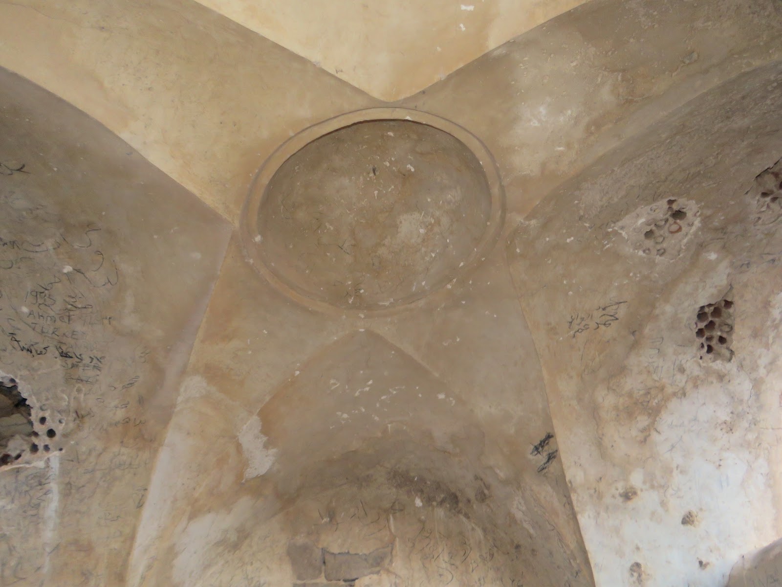
T. Canaan writes in his book on the Palestinian Muslim shrines, “Many a built maqam is an open sanctuary, where the walls of the roof rest on pillars. The best example of such a shrine is that of Hasan er-Ra'i, who was supposed to have been the shepherd of the prophet Moses. Inside of a rectangular enclosure, built of stones and mortar, we see an elongated and vaulted roof which rests on six pillars, three to the north and three to the south. Between these pillars is the large tomb” (1927, 17–18).
Then T. Canaan says, “Between the two northern vaults of the shrine of Hasan er-Ra‘i (near the Nebi Musa) we read: "Mohammed Pasha, the doer of good, has erected this blessed qubbeh on Hasan er-Ra‘i, God sanctify his secret, as he (the Pasha) was returning from welcoming the Mohammedan pilgrims. He proceeded in building but found no water. But because of his high zeal, God protect him, the water was brought to the place from the village of Jericho. Thus he deserved the heavenly reward. The 1 Rabi‘ 1110 (1698 AD)"” (1927, 20).
Now there is no this inscription there. The maqam's walls and columns have been plastered and painted a few times, and now they are covered with different inscriptions left by numerous pilgrims and tourists.
View from the east

Photo of 1934

Photo of 1934

Since 19th century, this shrine has been quite popular with visitors. Apparently, this tomb was seen by the Russian traveler A. Muravyov, passing in 1830 through Nabi Musa. In his book, he noted: “Near the monastery of dervishes (Nabi Musa) are the tombs of two sheikhs with a fresh spring for passing” (1840, II 27).
V. Guérin who visited the maqam in 1863, described it as follows, “At 10:10 we are passing a small fence with the wely in the centre. The welly is topped with two little domes and, also covers the remains of the saint. This kurgan chapel is called Qabr ar-Ra‘i. Ar-Ra‘i is a friend for the Muslims and a confidant of Nebi Musa or Moses” (Samarie I 20).
V. Guérin who visited the maqam in 1863, described it as follows, “At 10:10 we are passing a small fence with the wely in the centre. The welly is topped with two little domes and, also covers the remains of the saint. This kurgan chapel is called Qabr ar-Ra‘i. Ar-Ra‘i is a friend for the Muslims and a confidant of Nebi Musa or Moses” (Samarie I 20).
C. Clermont-Ganneau says, “the kubbeh of a small wely, called Kubbet er ra‘y, “the shepherd's cupola." Here, according to local tradition, rests Sheikh Hasan, the "Shepherd of Moses"” (ARP II 48). Ar-Ra‘i is derived from Arabic and means “shepherd”.
This shrine played an important role in a seven-day religious celebration (the Nabi Musa Festival), that was celebrated annually by Palestinian Muslims, beginning on the Friday before Good Friday in the old Greek Orthodox calendar.
View from the north-east

The cenotaph

The mihrab in the south side of a rectangular fence

What is more, T. Canaan noted that Qabr er-Ra‘i has three mihrabs (1927, 14). Nowadays there is one mihrab in the maqam, which is located in the south side of a rectangular fence (15 x 10 m). According to Canaan, “Earth gathered from Qabr er-Ra‘i dissolved in water and given to cattle will guard them from disease” (1927, 110).
Route. The maqam is located 850 m to the south-west from Nabi Musa. You can reach it via an asphalt road. Since 1995 the Palestinian National Authority have been taking control over the religious complex Nabi Musa and nearby shrines.
Visited: 06.08.18
Coordinates: 31°46'52.0"N 35°25'29.6"E
Location of the object on Google Maps
References: Muravyov 1840, II 27; Saulcy 1853, II 172 (“oualy Qobr-er-Raay”); Guérin, Samarie I 20 (“Kabr er-Ra’ai”); SWP III 231; Clermont-Ganneau, ARP II 48 (“Kubbet er ra‘y”); Canaan 1927, 14, 17–19, 20, 105, 110, 199 (“Qabr er-Ra‘i”); The Archaeological Survey of Israel
Addition: Panorama
Addition: Panorama
Maqam sitna ‘Aisha
مقام سيتة عايشة
קבר סתנא עיישא
Sitna (i.g. Lady) ‘Aisha was a beloved wife of Muhammad the Prophet. She was titled Umm al-Muminin (“the mother of the faithful”). She was worshipped by Sunnites as a hadith (the stories of the Prophet's life). She was traditionally buried at Jannat al-Baqi‘ cemetery in Medina. But also there is a tomb of sitna ‘Aisha in Palestine, nearby the shrine of Nabi Musa, to the east from Jerusalem.
View from the east

View from the north-west

T. Canaan called this shrine a masjid (mausoleum) and described it as follows, “Masdjid sittna ‘Aisha in the neighborhood of Nabi Musa has vault resting on four comer pillars, where the south side has been completely closed, and the eastern and western only partly built. A simple, square handsome building with the northern side completely opened, and the east and west sides partly open, stands on the site of the old enclosure. No tomb, cistern nor tree is connected with this place” (1927, 18, 61).
Photo 1900s

Photo 1930s

This description corresponds to what we see nowadays, though the structure was partly reconstructed. The building of the maqam can be dated to the 2nd half of the 19th century. Beautiful vaulted arches support the dome of the shrine. A small mihrab and the south wall are densely covered with Arabic inscriptions left by numerous pilgrims.
View from the north

The mihrab

The dome
Near the maqam there is a big Muslim cemetery, where you can see huge cenotaphs and tombstones. T. Canaan described this cemetery, “a cemetery, where those are buried who die during festival days. Notables who die in Jericho are very often brought here, and the ‘Idwan tribesmen of Transjordania bury some of their dead also in this cemetery. They count it a special blessing to be interred near this man of God” (1927, 194).
Visited: 06.08.18
Coordinates: 31°47'08.3"N 35°26'02.1"E
Location of the object on Google Maps
Maqam sheikh Mas‘ud
مقام الشيخ مسعود
קבר שייח' מסעוד
The maqam of sheikh Mas‘ud near Arabic city Drijat, on the top of Khirbet ad-Dereijat (Hurvat Dragot) is now the southernmost of the remaining Palestinian maqams.
V. Guérin who visited Khirbet ad-Dereijat on July 20th, 1863, noticed “a few caves, natural and artificial, where the nomad tribes were still living” (Judee, III 190). V. Gueren did not mentioned any shrine as well as a cemetery on the top of the hill.
This cemetery with the tomb of sheikh Mas‘ud appeared after the establishment of village Drijat, the exact date is unknown. According to the brickwork of the walls, it was built in 1970–1980s. The maqam has quite a modest size (4.75 х 4.75 х 1.80 m) and no mihrab which shows that the building was done in hastiness and with limited means.

View from the south

View from the west

View from the north-west

View from the north-east

There is a small cenotaph inside the maqam. When we were there, the whitewashed walls inside were stained with something like excrements. There were sooth stains on the ceiling.

Route. An asphalt road leads from Highway 35 to town Drijat. The cemetery with the maqam borders the town to the north.
Visited: 08.08.18
Coordinates: 31°18'13.3"N 35°04'42.0"E
Location of the object on Google Maps
References:
Guérin, Judee, III 190
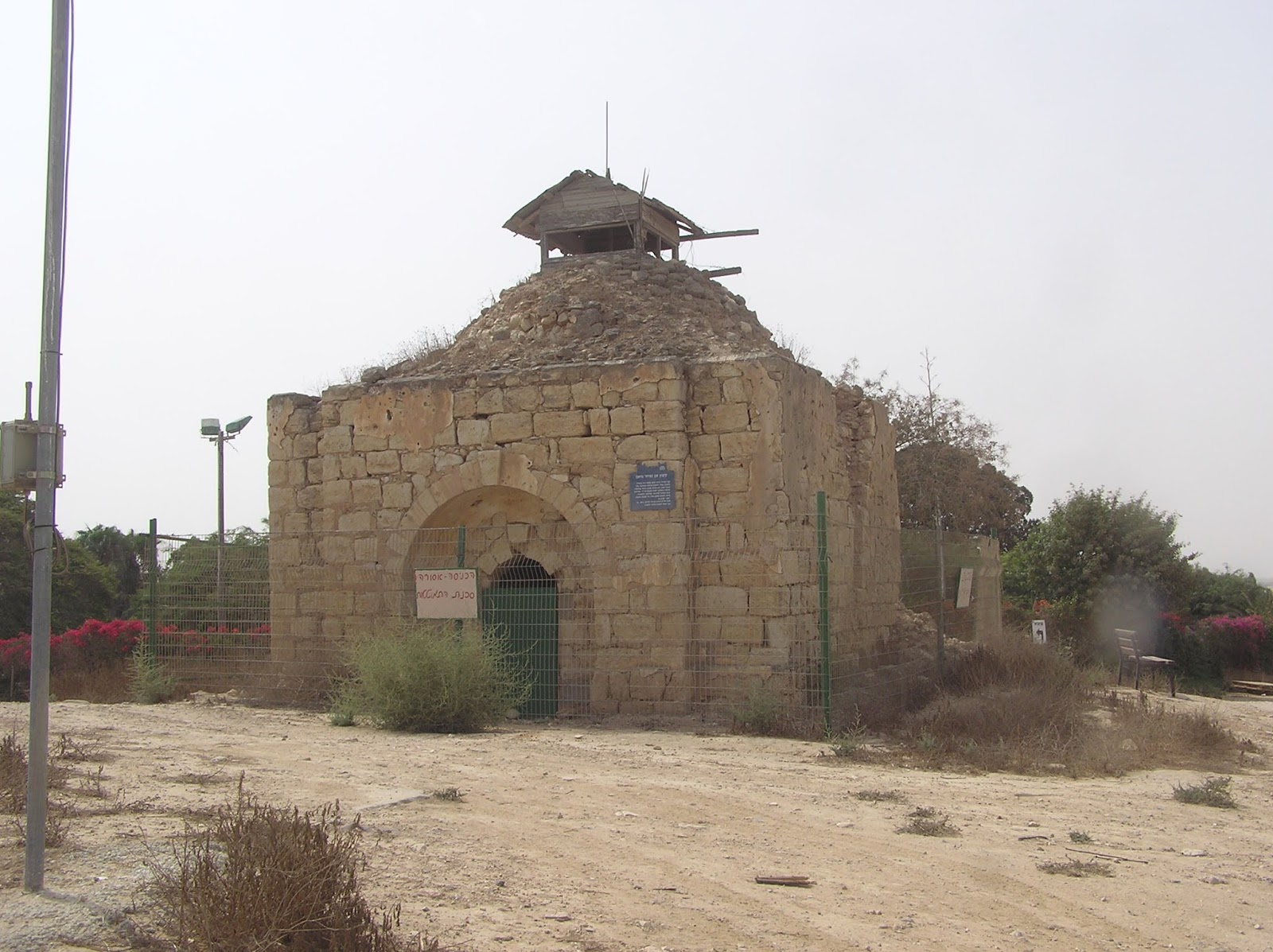
According to the number of documented uses, mainly in military sources, maqam of sheikh Nuran overcame other Muslim shrines and almost came up with the famous Rachel's Tomb in Bethlehem and Joseph's Tomb in Nablus. The matter is that the maqam of sheikh Nuran stands at a strategic position dominating over the neighborhood. Thus the Muslim shrine happened to be in the epicenter of fierce battles twice, in 1917 and 1948.
A plate attached to the maqam's wall says (Hebrew), “Sheikh Nuran's tomb was built in the 19th century at the lowest point of the district. It was made of stones taken from the ruins of the archaeological object of the Byzantine period. During the I WW the tomb was used as a Turkish military position and after the British seizure it was renovated as a gift to Bedouins. During the Independence War it has been a Egyptian position until it was occupied during Asaf military campaign (5.12.48). After kibbutz Magen was established (16.8.49), the position was turned into a watchtower”.
It's worth mentioning that on the first map of this region published by PEF in 1900, the shrine is marked as Nabi (Prophet) Nuran.
Nuran was an old man and keeper of Bedouin tribe Tarabin. There were many legends about him. His name is thought to be derived from Arabic name “nur” – “light”. It was said that the majority of tombs were miscarriage victims or babies who died in their cots. All Bedouins in Negev worshipped this place of a special sanctity.
During the World War I the Turkish people built a railway line and established their positions there trying to hold back the troops of General Allenby. Maqam was severely suffered from bombing. When the British soldiers seized this strategic point in February 1917, they set up camp, built a railroad station and aerodrome.
After the victory, the Englishmen fully restored sheikh Nuran's maqam. Thus, they acknowledged the Bedouin tribes for their support during the war against Turkey. The illustrative photos were shown to the whole world.

Map by PEF 1900

During the 1948 Arab-Israeli War the Egyptian soldiers set their position near the maqam. There is a photo evidence of that time. In December Israeli Golani Brigade took control over the height. The Egyptians tried to fight it back, a few times committed counterattacks, but in vain.
The Israeli people used the Bedouin's sanctuary as a watchtower or firing point. Next year Magen kibbutz was established by the Jewish people, where the maqam is kept as a memory about the victory in the 1948 War.


The Jewish did not follow the example of Britishmen and did not restore the maqam. Having been included into the Israeli history, the Bedouin sanctuary is still disfigured. There are 4 balks – pillars of the Israeli watchtower which is set as a wooden hut above the maqam. You can climb up to the hut by stairs through a big round hole cut in the dome of the maqam. Of course, there are no signs of a cenotaph of sheikh Nuran, which was abolished in 1948. What is more, there is no mihrab in the maqam, and probably it hasn't been there since the very beginning.
Maqam sheikh Nuran
مقام الشيخ نوران
קבר שייח' נוראן
According to the number of documented uses, mainly in military sources, maqam of sheikh Nuran overcame other Muslim shrines and almost came up with the famous Rachel's Tomb in Bethlehem and Joseph's Tomb in Nablus. The matter is that the maqam of sheikh Nuran stands at a strategic position dominating over the neighborhood. Thus the Muslim shrine happened to be in the epicenter of fierce battles twice, in 1917 and 1948.
A plate attached to the maqam's wall says (Hebrew), “Sheikh Nuran's tomb was built in the 19th century at the lowest point of the district. It was made of stones taken from the ruins of the archaeological object of the Byzantine period. During the I WW the tomb was used as a Turkish military position and after the British seizure it was renovated as a gift to Bedouins. During the Independence War it has been a Egyptian position until it was occupied during Asaf military campaign (5.12.48). After kibbutz Magen was established (16.8.49), the position was turned into a watchtower”.
It's worth mentioning that on the first map of this region published by PEF in 1900, the shrine is marked as Nabi (Prophet) Nuran.
Nuran was an old man and keeper of Bedouin tribe Tarabin. There were many legends about him. His name is thought to be derived from Arabic name “nur” – “light”. It was said that the majority of tombs were miscarriage victims or babies who died in their cots. All Bedouins in Negev worshipped this place of a special sanctity.
During the World War I the Turkish people built a railway line and established their positions there trying to hold back the troops of General Allenby. Maqam was severely suffered from bombing. When the British soldiers seized this strategic point in February 1917, they set up camp, built a railroad station and aerodrome.
After the victory, the Englishmen fully restored sheikh Nuran's maqam. Thus, they acknowledged the Bedouin tribes for their support during the war against Turkey. The illustrative photos were shown to the whole world.
Photo of 1934


During the 1948 Arab-Israeli War the Egyptian soldiers set their position near the maqam. There is a photo evidence of that time. In December Israeli Golani Brigade took control over the height. The Egyptians tried to fight it back, a few times committed counterattacks, but in vain.
The Israeli people used the Bedouin's sanctuary as a watchtower or firing point. Next year Magen kibbutz was established by the Jewish people, where the maqam is kept as a memory about the victory in the 1948 War.
Photo of 1948

Photo of 1948

Photo of 1948

The Jewish did not follow the example of Britishmen and did not restore the maqam. Having been included into the Israeli history, the Bedouin sanctuary is still disfigured. There are 4 balks – pillars of the Israeli watchtower which is set as a wooden hut above the maqam. You can climb up to the hut by stairs through a big round hole cut in the dome of the maqam. Of course, there are no signs of a cenotaph of sheikh Nuran, which was abolished in 1948. What is more, there is no mihrab in the maqam, and probably it hasn't been there since the very beginning.
Photo of 1950


View from the north-east
View from the south

The maqam's interior

The maqam's interior


Route. The maqam is located in the northern outside part of Magen kibbutz, which can be reached via Highway 232.
Coordinates: 31°18'01.0"N 34°25'26.2"E
Location of the object on Google Maps
References: Canaan 1927, 11; NIG 2001, XIV 222
Pemakaman islam I think this is an informative post and it is very useful and knowledgeable. therefore, I would like to thank you for the efforts you have made in writing this article.
ReplyDeleteThank you.
DeleteЗдравствуйте Борис.
ReplyDeleteВы меня заинтересовали.Как вы вышли на такую тему как "Muslim Shrines".
Я сам занимаюсь исследованием истории Палестины.Это мой хобби последние
20 лет.Впредь извиняюсь за мой Русский.приехал в Израиль в 10 летнем возрасте.Я сначала не заметил что вы не еврей поэму был удивлен вашим
интересом.Какие исторические темы вас интересуют?
Добрый день. Меня много чего интересует. Представьтесь и скажите пару слов о себе, если можно.
Delete