Mosque in Kafr ‘Aqab
مسجد في كفر عقاب
מסגד בכפר עקיב
According to the photos made just after the Six-Days War in 1967, the mosque in Kafr ‘Aqab stood in the middle of the village. Now there is only a basement of the mosque and 1–1.5 m high walls on the hill. Almost nothing left from the minaret.
Photo of 1968

View from the south

View from the south-west

Route. On 20th km turn from Highway 92 to moshav Ramot and in 250 m to the left there is a hill with the ruins of Kafr ‘Aqab village.
Visited: 21.08.15
Coordinates: 32°51'46.4"N 35°39'16.1"E
Location of the object on Google Maps
References: The Archaeological Survey of Israel
Mosque in Khushniya
مسجد في الخشنية
מסגד בחושניה
This mosque is observable for all who take Highway 87 and pass a former Syrian (Cherkess) village Khushniya, as the mosque stands right near the road. It was built just before the Six-Days War and now is the only object left after Khushniya. The mosque is often made photos of due to its beautiful minaret with two rounded balconies.
The building is relatively safe, besides the south-western corner, which was destroyed during the 1967 war. The south wall with the mihrab is covered with Arabic and Jewish inscriptions left by modern visitors.


Route. The mosque is said to stand on Highway 87, between the crossroads of Keshet and Bashan.
Visited: 05.10.11
Coordinates: 32°59'55.2"N 35°48'39.7"E
Location of the object on Google Maps
Mosque in ‘Uweynat al-Janubiyeh
مسجد في عوينة الجنوبية
מסגד של הכפר עווינאת
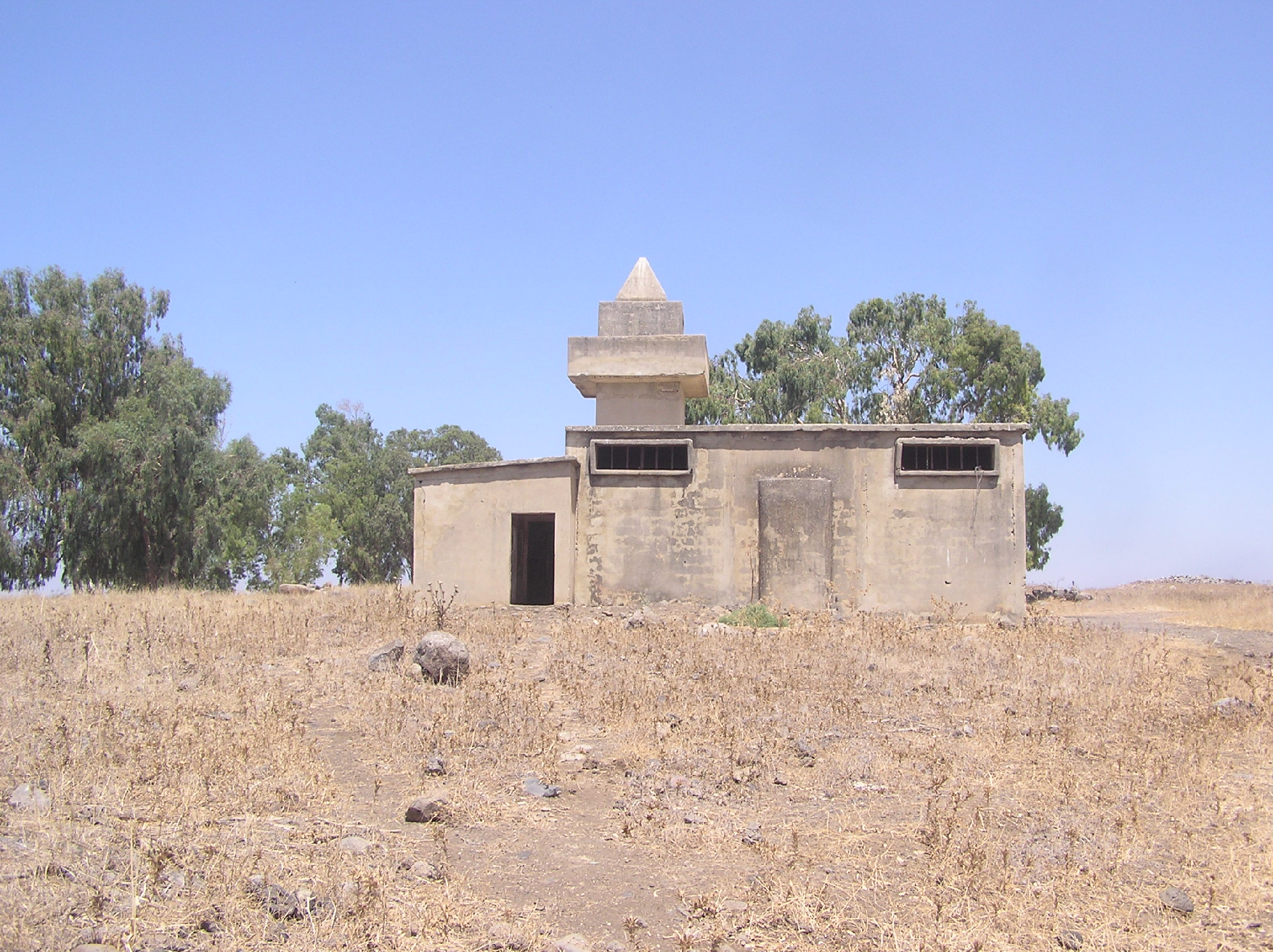
There were a few Syrian and Cherkess mosques in the Golan Heights, but almost all of them are destroyed now. One of the saved; mosques is located in the former village ‘Uweynat al-Janubiyeh (1.5 km to the west from Israeli moshav Kidmat Tsvi).
This mosque was built in 1950-s for the Syrian soldiers who were allocated in ‘Uweynat al-Janubiyeh. The exterior of the building looks like military barracks: the concrete walls, narrow firing windows, a squat four-corner minaret which resembles a watch-tower.
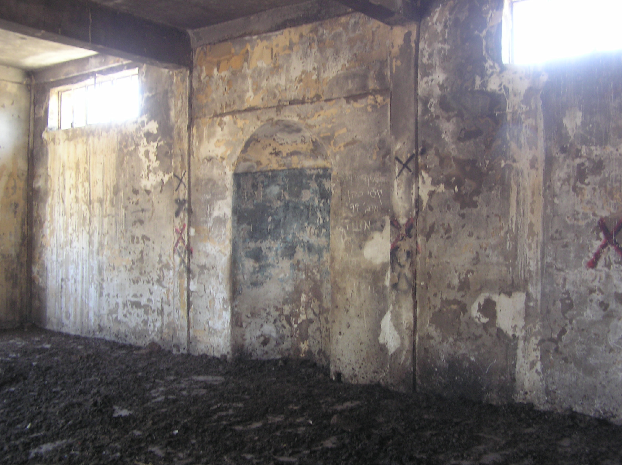
When the Golan Heights were occupied by Israel in 1967, village ‘Uweynat al-Janubiyeh became depopulated. The mosque still stands on the hill, but one cannot enter as the floor is covered with excrements. That is because the Jewish settlers from Kidmat Tsvi were keeping the cattle there; and when there were too much manure, they took the cattle to another place and did not clean the mosque.
This mosque was built in 1950-s for the Syrian soldiers who were allocated in ‘Uweynat al-Janubiyeh. The exterior of the building looks like military barracks: the concrete walls, narrow firing windows, a squat four-corner minaret which resembles a watch-tower.
When the Golan Heights were occupied by Israel in 1967, village ‘Uweynat al-Janubiyeh became depopulated. The mosque still stands on the hill, but one cannot enter as the floor is covered with excrements. That is because the Jewish settlers from Kidmat Tsvi were keeping the cattle there; and when there were too much manure, they took the cattle to another place and did not clean the mosque.
View from the south
The mihrab
Route. From the 16th km of Highway 91 (after crossroad Nashot) turn right to the North, to a track road leading to Nahal Gilbon (Jalaboun Stream). The mosque is 850 m from the turn.
Visited: 21.08.15
Coordinates: 33°02'09.9"N 35°40'51.1"E
Location of the object on Google Maps
References: The Archaeological Survey of Israel
No comments:
Post a Comment