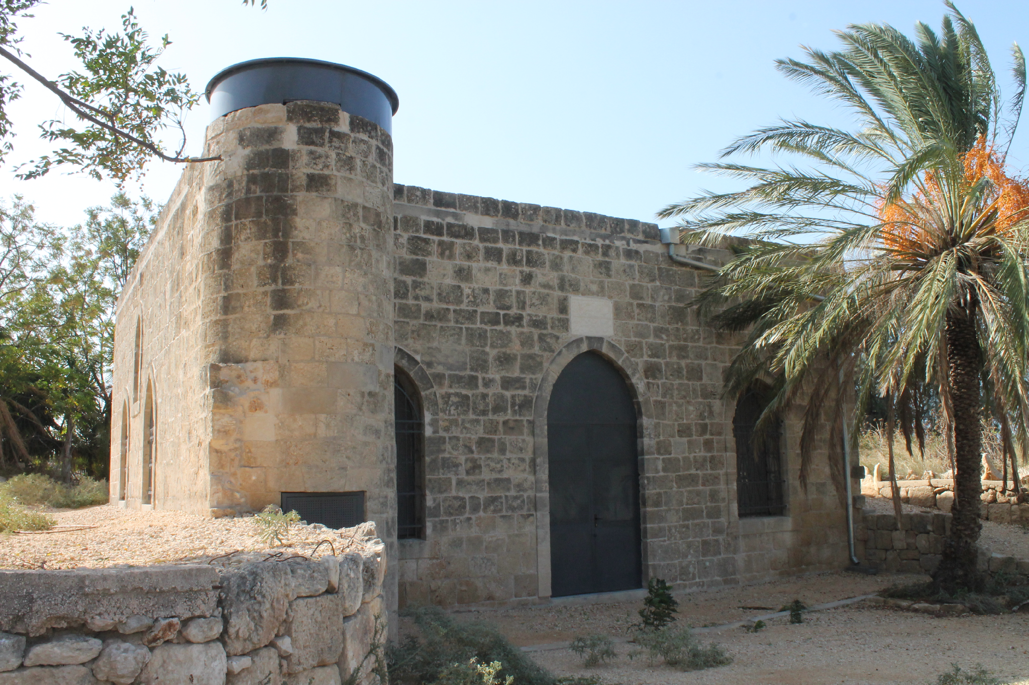
Mosque in ‘Amqa
مسجد في عمقا
מסגד בעמקה
The exterior of this mosque looks like the mosque in al-Ghabisiya (see next): the same beautiful three-arched portique (riwaq), approximately the same size of the Prayer hall decorated with high arched curves. Obviously, the mosque in ‘Amqa was built in the 19th century too. As in other villages of the Upper Galilee, the Druzes lived in ‘Amqa.


View from the north

View from the north-west

Photo of 1990s

In September 1991, the mosque was studied by A. Petersen and made a detailed description, “This structure is located at the highest point of the rocky hillside on which the village was built. It is the only surviving building from the Arab village with the exception of a schoolroom now used as a warehouse (Khalidi 1992, 5).
The mosque consists of a domed prayer hall and an open portico (riwaq) divided into three cross-vaulted bays, each open to the north. The portico also has an open arch at the east end and a rectangular window at the west end. The area in front of the portico (now overgrown) was an open paved courtyard containing a deep cistern in the middle.
The prayer hall is entered through a doorway in the centre of the portico. Its hall is a large square room with massive corner piers supporting the springing of the dome. The interior is lit by a pair of windows on the west and east sides and windows either side of the main door. The area between the piers form wide recesses covered with tall arches. There is a small concave mihrab set into the south wall, slightly to the left (east) of centre, possibly to accommodate the minbar (now vanished) on the west side.
The dome rests directly on the pendentives without the intervention of a drum. The roof of the building is reached by a set of steps within the thickness of the west wall. The staircase is entered from a doorway set into the exterior of the west wall. The exterior of the dome and the flat parts of the roof are coated in a thick grey waterproof plaster. The lower part of the dome has near vertical sides whilst the upper portion has a shallow slightly pointed form. The entire structure is built out of ashlar masonry with a white plaster coating on the interior” (2001, 93).
Entrance to the mosque

Mihrab in the south wall

Western wall


The dome

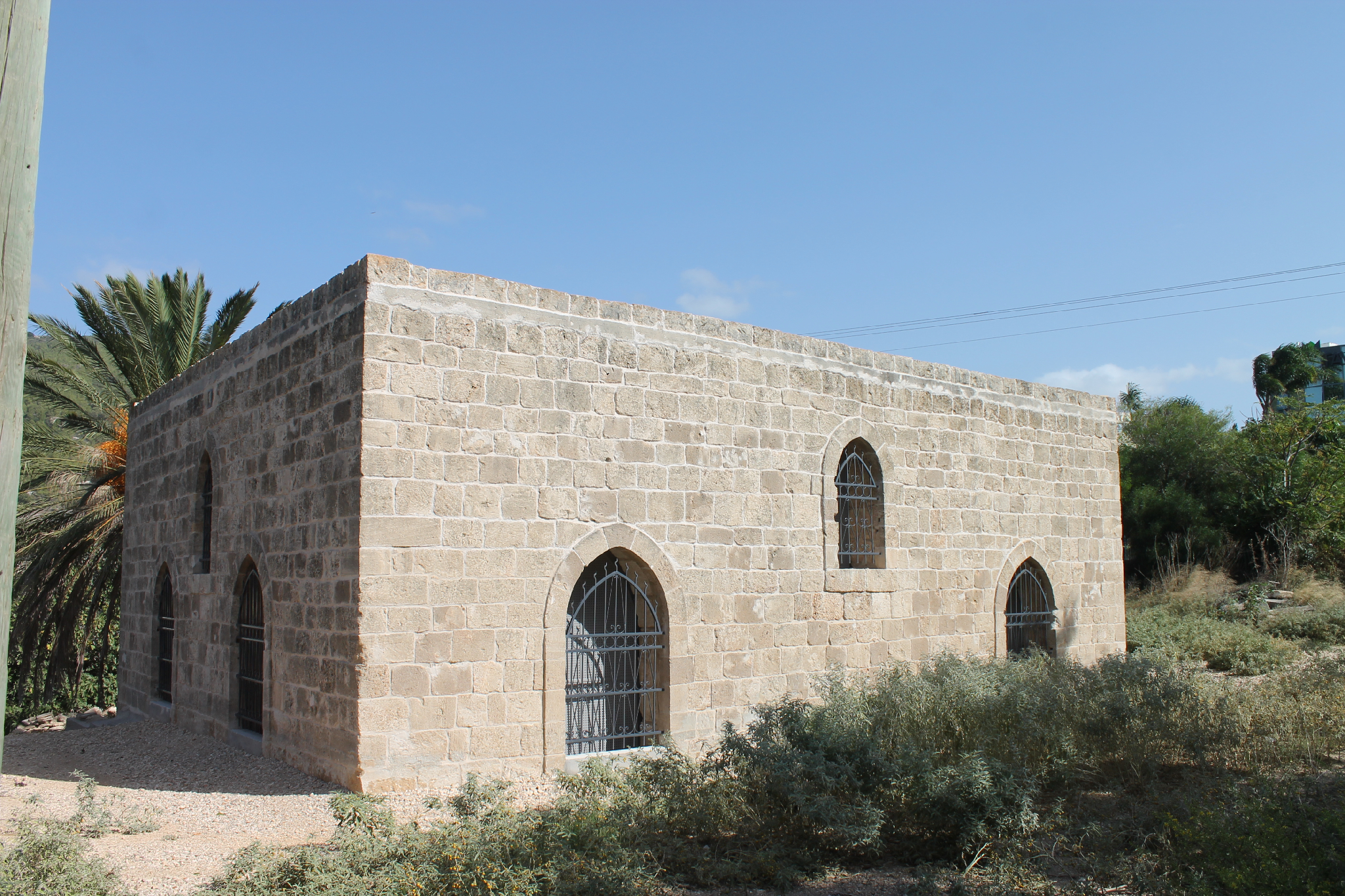
Over 25 years the abandoned mosque looks quite the same way. Only the destruction process speeded up: the entrance to the Prayer hall is damaged, the east wall partly collapsed, as well as a mihrab in the south wall. Though the damages are not disastrous, the monument is in danger. The fallen wreckage with rubbish are heaped in front of the entrance to the mosque.
From time to time the organization Zochrot organizes excursions for refugees and their descendants in village ‘Amqa. Though we did not see any Muslim traces in the mosque.
Route. There is a turn from Highway 70 to a road leading to Israeli settlement ‘Amqa. You should pass the settlement till the eastern suburbs where there stands the abandoned mosque on the waste land.

Visited: 20.08.15
Coordinates: 32°58'38.2"N 35°10'05.0"ELocation of the object on Google Maps
References: Guérin 1880, Galilée II, 23; Khalidi 1992, 5; Petersen 2001, 93; The Archaeological Survey of Israel
Mosque in al-Bassa
مسجد في البصة
מסגד בבצת
A. Petersen commented this mosque as follows, “This appears to be a fairly modern construction, probably built in the early 1900s. It consists of a tall square room with a flat roof supported by iron girders. At the north-east corner is a short cylindrical minaret. There are tall pointed windows on all four sides and a mihrab in the middle of the south wall. At present the building is used as a sheep pen” (2001, 111).
View from the north
View from the south-east
Now this moque is located in the Industrial zone Shlomi, 50 m to the west from Maqam al-Khidr (see Section 7. Maqams. Galilee and the Golan Heights). In the the 1990s there was also a sheep pen, now the mosque is used like it was meant for. The Muslims restored it, installed a gutter, put a lock on the door and totally enclosed all the windows with iron bars and curtains. The majority of time the mosque is blocked. Only sometimes when Muslim pilgrims come there, the mosque is open and a prayer is exercised there.
It is strange that the Muslim took care of the mosque, but they forgot about their own shrine – Maqam al-Khidr, which is located nearby, over a street. This maqam keeps destroying.
Route. You can reach the mosque via Highway 899, which passes through Israeli settlement Shlomi. At the central crossroad you should turn to the north, to the Industrial zone.

Coordinates: 33°04'42.4"N 35°08'33.6"E
Location of the object on Google Maps
References: Khalidi 1992, 6–9; Petersen 2001, 111
Former Palestinian village al-Ghabisiya is famous for its mosque. Even V. Guérin was among those who was enchanted by the high cypresses standing in the yard. Now there is only one cypress in the yard. The French explorer noted that the building as you see was built partly from ancient materials often found on the territory (Galilee II 30). According to Guérin, the mosque was established during the times of ‘Ali Pasha, before 1818.


Here goes A. Petersen's description of the mosque, “The mosque consists of a large (10m x 30m) rectangular walled complex built around a central courtyard. The complex is entered through a doorway in the west wall of the enclosure. The paved courtyard contains a cistern, date palms, and a tall cypress tree (presumably one of those seen by Guerin in the 1860s). At the north end of the courtyard is a vaulted room presumably used for religious education. A staircase built into the thickness of the west wall of the compound leads up to the roof.
At the south end of the courtyard is a tall portico (riwaq) divided into three cross-vaulted bays. At the back of the east and west bays there are windows (one on each side) opening from the prayer hall of the mosque. A single doorway in the back of the central bay of the portico leads into the prayer hall. Both the windows and the doors are covered with shallow round arches.
The interior of the prayer hall is a rectangular space with a dome covering the central area and two narrow cross-vaults covering the two side areas. The dome is supported by arches springing from tall thin piers. There is a plain mihrab centrally placed in the south wall and the remains of a fixed stone minbar. The east and west walls are each pierced by two windows, one near floor level and one at roof level. In addition there is a rectangular window above the mihrab” (2001, 140).


Now there there is only a cistern and one cypress in the mosque's yard. The palm trees that A Petersen mentioned were destroyed, though there is a piece of palm tree trunk in the north-eastern corner of the yard. The doorway in the west wall which was used as the entrance to the yard, is now blocked with an iron shield. Anyway, we managed to get to the yard over the half-ruined south wall. You still can use the stone stairs to climb up to the roof where you can observe a picturesque view of the seashore flatland. But you should move carefully there.
When al-Ghabisiya was abandoned, the Israeli Arabs attempted to restore the mosque a few times and make it appropriatge for pray, but the authorities do not allow to proceed any works. For more details read Wikipedia.

Route. Former Palestinian village al-Ghabisiya was located on the hill 1 km to the north from current village Sheikh Danun. To reach the mosque you should turn from Highway 70 (77th km) to the track road which starts at the entrance of the present Jewish cemetery.
Visited: 20.08.15
The Crusading castle Castellum Novum (now Mezudat Hunin) was partly turned by Muslims into a mosque: thay changed a bit inner rooms and added a minaret. An Arabic inscription found in Hunin says that the mosque was built in the mid 19th century. Though M. Sharon who published this inscription, thinks that it is another mosque built in the village (2007, 109). As a majority of the South Lebanon residents, the residents of Hunin were Shiites.
Ch. Van de Velde was the first who mentioned about the mosque, when he was in Hunin in 1851, “There is a half ruined mosque with a small tower at the southeastern comer of the edifice, outside the walls of the citadel. This mosque is ornamented with carved work, and two marble stones have on them Arabic inscriptions, carved in haul-relief” (1854, I 169).
V. Guérin added to the description of the mosque, “A small mosque, half-restored, and decorated with an octagonal minaret topped with a lamp for eight windows. Twenty water reservoirs are placed in the yard” (Galilee, II 371).
A. Petersen visited Hunin in 1993 when the mosque has completely disappeared, “The mosque stood opposite the castle gatehouse and has now entirely disappeared. Photographs taken during the Mandate period show that the building was already in ruins, although a tall octagonal minaret was still standing (Plates 114–115). An inscription (now lost) found within the mosque referred to the construction of the building in 1166 H. (1752–1753 C.E.). The area is now covered with trees” (2001, 150).
Route. You may reach Mezudat Hunin by taking Road 9977 (before Margaliot crossroad) and turn to the asphalt road leading to moshav Margaliot.


Visited: 05.10.11
A mosque in former Palestinian village Ijzim is referred to the most beautiful and biggest religious buildings inactive since 1948. Now all the entrances to the mosque are not just closed, but welded up tightly to prevent any invasion inside.
A few travelers of the past mentioned this mosque in their travel notes. V. Guérin who visited Ijzin in 1863 “noticed in the doorway of the mosque a marble column taken from an ancient building” (Samarie II 300). In the early 19th century E. Mulinen visited Ijzim and took a few photos of the mosque, and one of them was published in Deutschen Palästina-Vereins (XXXI 203). At the at time the mosque was still active.


In 1994 A. Petersen carefully watched all the rooms of the mosque and made a description as follows, “This is a large courtyard complex standing on the slope of the hill to the north of the 'castle'. The mosque is built on a terrace which on one side is over 4m high. The complex comprises four main elements; the courtyard, the prayer hall, an arcade, and a range of other rooms.
The courtyard has two gateways, one from the north, and the other on the south side facing the 'castle'. The courtyard is a rectangular (19.45m x 12.2m) area paved with large flagstones. On the west side of the courtyard is the arcade, to the south the prayer hall, and to the east a range of rooms. At the south-east corner of the courtyard is a set of covered steps leading up to the roof. The north side of the courtyard is bounded by a low (1m) enclosure wall with a gate at the east end. In the north-west corner of the courtyard is an entrance to a deep cistern.
The arcade comprises three domed bays opening on to the courtyard. On the west side of the arcade is a wall with a pair of windows for each bay. At the south end of the arcade is a mihrab with flanked engaged pilasters with carved foliate capitals. At the north end of the arcade is a window looking over the Carmel.
The entrance to the prayer hall is a very prominent feature flanked by two plain arched windows. The door panel is set within a rectangular frame, containing a shallow niche, with a trefoil arch at the top, which in turn contains the rectangular doorway. The outer edge of the arch is outlined by a billet moulding. In the tympanum of the arch is an inscription and two panels of low relief carving above. At the apex of the arch is a formalized depiction of a vase with flowers, below this is a rectangular panel of geometric decoration consisting of interlocking diagonally positioned squares. The inscription is on a marble panel which appears to be larger than the space originally intended (it is possible that this is a replacement of an earlier inscription). The panels consists of six lines of naskhi inscription in two rows with the date 1226 H. (1811–1812 C.E.) in a separate cartouche below. Either side of the date is a five-pointed star and a cypress tree.
The prayer hall is a large rectangular space (14m x 7.35m) with a large central vault and two side vaults. The apex of each vault is decorated with a star pattern containing a central raised dome. The mihrab in the centre of the south wall is of similar design to the external mihrab with columns either side of a wide niche” (2001, 152, 154).
The Archaeological Survey of Israel has following information: “The village mosque, constructed in the Ottoman period of limestone blocks and kurkar stones, stands to the north of the building. Its entrance (1.4 × 2.0 m) leads to an expansive courtyard; an ancient marble column (in secondary use) was fixed at the threshold. The courtyard is paved with limestone slabs and surrounded by structures on three sides. Near the entrance is a dedicatory inscription in Arabic: “The mosque was renovated by Mas‘ud, patriarch of the Mahdi family, in the year 1236 AH” (1821 CE). The inscription clearly replaces an earlier one. Above it is a short Arabic inscription: “In the name of the merciful and compassionate Allah”. The prayer hall is located to the right of the courtyard’s entrance. The mihrab, in the south wall of the prayer hall, is constructed of two pillars topped by basket capitals. There is no minaret; the muezzin called the faithful to prayer from the mosque roof, ascended via a staircase consisting of 26 steps. On the south side of the mosque’s courtyard — a prayer hall, whose roof is supported by two columns”.


Unfortunately, all this is now impossible to observe. When coming around the blocked mosque from the northwestern side, you can see overwhelming massiveness of the building.
You cannot say that the mosque is subject to destruction, but a few crashes might have happened inside the mosque. It is known that in 1949 moshav Kerem Maharal was established on the place of Palestinian Ijzim, and the first settlers lived in the mosque, later it was used as a storage.
Route. The abandoned mosque is located in the centre of modern moshav Kerem Maharal, where ha-Tel and ha-Khan street cross. There is no sign about this.

Visited: 18.08.15
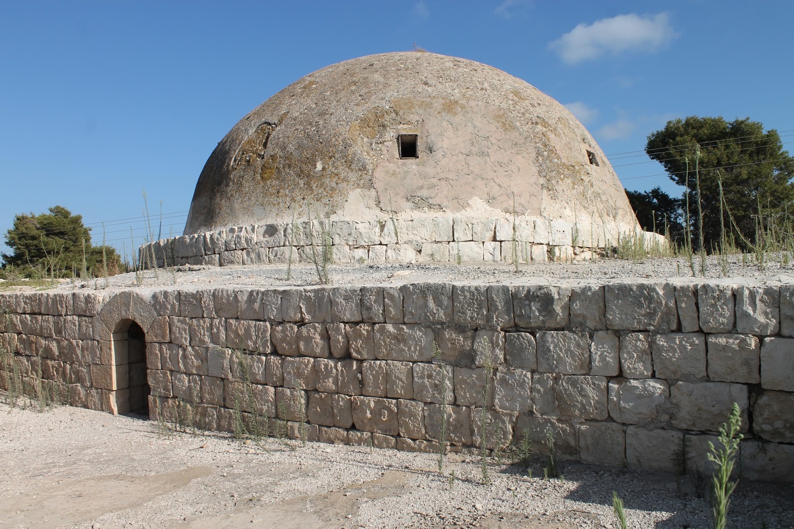
V. Guérin who visited Khirbet Bassum in 1863 described it as an abandoned village (Galilée I 265), and it still stays so. Consequently, a mosque saved there has also been abandoned at least for 1.5 century As A. Petersen says, “This is a rectangular domed structure built into the hillside. There is a low entrance in the middle of the north wall. The doorway leads directly into a central domed area with a mihrab in the south wall. Either side of the domed area are vaulted galleries, each of which is approximately 5m long” (2001, 111).


The mosque consists of black basalt stones – a usual building material of the eastern part of Galilee and the Golan Heights. Somewhere there left whitewash which covered the wall and dome of the mosque. There are Hebrew inscription on the inner and outer walls.


Modern Jewish authors are trying to attribute this structure to the Biblical history. Namely, it is supposed to consider it as the tomb of Jael, wife of Heber the Kenite, though nothing in this structure tells about a cenotaph being there. Anyway no measures regarding judaisation of this mosque were taken.
Route. A 3 km track road leading from Yavne'el to the north-west, to Khirbet Bassum (Hebrew: Horvat Evtzam) is almost not accessible for a car. Though we managed to reach it, it's better to take a jeep to move on such a road.


Visited: 21.08.15
In 1945 the locals of Palestinian village al-Manshiya (nearby Acre) built a new spacious mosque with a beautiful white dome. But they had only 3 years to pray in this mosque. In 1948 al-Manshiya was taken by the Israeli troops, and he residents left the village.
The abandoned mosque remained intact. Now it is located in the new quartal of Israeli town Akko. The local authorities are trying to keep this mosque safe, as well as other historic and cultural monuments in the different part of the town.
However, it wasn't the only bad luck for the mosque. In 2006 the Jewish religious extremists set the mosque on fire, and it was in fire till the fire brigade came. After that the municipality of Acre the mosque was walled with a metal bar fence without a gate or any other entry.
But that did not spot the extremists. In 2010 the mosque was again desecrated. A Hebrew inscription “Kill the Arabs!” appeared on its white dome. The photos of the desecrated mosque were printed in newspapers. The municipality painted this inscription and set a new very high metal bar fence.

When going round this mosque we saw that it was fully blocked: the entrance from the northern side, and arched windows. It's just a dead brick crypt. Obviously, it was done according the municipality decision.
Route. Now the territory of the former Palestinian village al-Manshiya is within Acre city, in the quartal which street Yehud Burla is going round of.

Visited: 19.08.15
According to the table set near the abandoned building, this small mosque was built in 1936. That means it was active only for 12 years. Now the entrance to the mosque in the north wall is bricked up. The staircase on the east side of the building leads tho the roof where in the south-west corner there are remains of a small square minaret.

W. Khalidi visited the former Palestinian village as-Sumayriya in 1987 and described it as follows, “One room from the mosque, portions of a building, segments of walls and arches from fallen houses, and graves are all that remain of al-Sumayriyya. The remaining part of the mosque is a square stone building with a flat roof that is supported on girders and crossbeams. It has a round-arched doorway that is presently closed. Most of the site is covered by a forest of eucalyptus trees interspersed with bushes and wild grass. There is a cowshed on the site's northern section. The lands in the vicinity are cultivated by the settlement of Regba” (1992, 31). The explorer did not mentioned about a small Muslim cemetery located to the south from the mosque and now covered with bushes.

There are remains of the Crusader castle to the north from the mosque.
Route. Palestinian village as-Sumayriya was located between kibbutz Lohamei ha-Geta'ot and moshav Regba. The mosque is well observed from Highway 4. You can reach it turning from the Highway to the Shopping centre of moshav Regba.

Visited: 19.08.15
Nothing in the exterior of a present synagogue of Tirat Carmel looks loke a former mosque of the Palestinian village at-Tira. The mosque itself was built on the basement of a Byzantine church.


V. Guérin visited in 1870, “I first examined a small mosque, which appears to have been formerly a Christian church. Aligned from west to east it has only a single nave and is terminated towards the east by an apse. One enters through a rectangular door crowned by a fine monolithic lintel. This church, which has been constructed with very regular ashlars, is covered by slightly pointed vaults, above which there is a flat terrace roof” (Samarie II 282).
A. Petersen noted as follows, “A sketch plan of the mosque made in 1932 shows a rectangular prayer hall with a large courtyard to the north. The courtyard had rooms on the west and east sides and was entered through a doorway in the north wall. The entrance to the prayer hall was a door set in an arched recess containing an inscription. The inscription written in provincial naskhi records the construction of the mosque by Ishaq ibn Amir in 687 H. (1288–1289 C.E). The interior of the mosque is divided into six vaulted bays springing from corner piers and resting on two central columns. The columns are capped with reused antique Corinthian capitals” (2001, 306).

Mosque in al-Ghabisiya
مسجد في الغابسية
מסגד בע'אבסייה
Former Palestinian village al-Ghabisiya is famous for its mosque. Even V. Guérin was among those who was enchanted by the high cypresses standing in the yard. Now there is only one cypress in the yard. The French explorer noted that the building as you see was built partly from ancient materials often found on the territory (Galilee II 30). According to Guérin, the mosque was established during the times of ‘Ali Pasha, before 1818.
View from the north

View from the north

View from the west

View from the soth-west

The north-eastern corner of the yard

Here goes A. Petersen's description of the mosque, “The mosque consists of a large (10m x 30m) rectangular walled complex built around a central courtyard. The complex is entered through a doorway in the west wall of the enclosure. The paved courtyard contains a cistern, date palms, and a tall cypress tree (presumably one of those seen by Guerin in the 1860s). At the north end of the courtyard is a vaulted room presumably used for religious education. A staircase built into the thickness of the west wall of the compound leads up to the roof.
At the south end of the courtyard is a tall portico (riwaq) divided into three cross-vaulted bays. At the back of the east and west bays there are windows (one on each side) opening from the prayer hall of the mosque. A single doorway in the back of the central bay of the portico leads into the prayer hall. Both the windows and the doors are covered with shallow round arches.
The interior of the prayer hall is a rectangular space with a dome covering the central area and two narrow cross-vaults covering the two side areas. The dome is supported by arches springing from tall thin piers. There is a plain mihrab centrally placed in the south wall and the remains of a fixed stone minbar. The east and west walls are each pierced by two windows, one near floor level and one at roof level. In addition there is a rectangular window above the mihrab” (2001, 140).
There is a plain mihrab centrally placed in the south wall and the remains of a fixed stone minbar

The east wall

The dome
Now there there is only a cistern and one cypress in the mosque's yard. The palm trees that A Petersen mentioned were destroyed, though there is a piece of palm tree trunk in the north-eastern corner of the yard. The doorway in the west wall which was used as the entrance to the yard, is now blocked with an iron shield. Anyway, we managed to get to the yard over the half-ruined south wall. You still can use the stone stairs to climb up to the roof where you can observe a picturesque view of the seashore flatland. But you should move carefully there.
When al-Ghabisiya was abandoned, the Israeli Arabs attempted to restore the mosque a few times and make it appropriatge for pray, but the authorities do not allow to proceed any works. For more details read Wikipedia.

Route. Former Palestinian village al-Ghabisiya was located on the hill 1 km to the north from current village Sheikh Danun. To reach the mosque you should turn from Highway 70 (77th km) to the track road which starts at the entrance of the present Jewish cemetery.
Visited: 20.08.15
Coordinates: 33°00'03.2"N 35°09'02.6"E
Location of the object on Google Maps
References: Guérin, Galilee II 30–31 ; Khalidi 1992, 15; Petersen 2001, 140; The Archaeological Survey of Israel
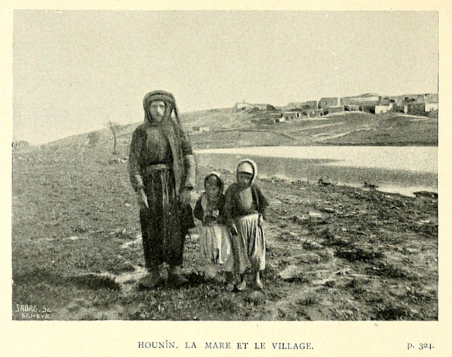
Mosque in Hunin
مسجد في هونين
מסגד בהונין
The Crusading castle Castellum Novum (now Mezudat Hunin) was partly turned by Muslims into a mosque: thay changed a bit inner rooms and added a minaret. An Arabic inscription found in Hunin says that the mosque was built in the mid 19th century. Though M. Sharon who published this inscription, thinks that it is another mosque built in the village (2007, 109). As a majority of the South Lebanon residents, the residents of Hunin were Shiites.
Ch. Van de Velde was the first who mentioned about the mosque, when he was in Hunin in 1851, “There is a half ruined mosque with a small tower at the southeastern comer of the edifice, outside the walls of the citadel. This mosque is ornamented with carved work, and two marble stones have on them Arabic inscriptions, carved in haul-relief” (1854, I 169).
V. Guérin added to the description of the mosque, “A small mosque, half-restored, and decorated with an octagonal minaret topped with a lamp for eight windows. Twenty water reservoirs are placed in the yard” (Galilee, II 371).
Photo of 1898 (from the book by L. Gautier)

A. Petersen visited Hunin in 1993 when the mosque has completely disappeared, “The mosque stood opposite the castle gatehouse and has now entirely disappeared. Photographs taken during the Mandate period show that the building was already in ruins, although a tall octagonal minaret was still standing (Plates 114–115). An inscription (now lost) found within the mosque referred to the construction of the building in 1166 H. (1752–1753 C.E.). The area is now covered with trees” (2001, 150).
Route. You may reach Mezudat Hunin by taking Road 9977 (before Margaliot crossroad) and turn to the asphalt road leading to moshav Margaliot.


Visited: 05.10.11
Coordinates: 33°13'14.9"N 35°32'39.9"E
Location of the object on Google Maps
References: Van de Velde 1854, I 169; Robinson 1856, 371; Guérin, Galilee, II 371; Baedeker 1882, 403; Gautier 1898, 321, 323; Khalidi 1992, 454–455; Petersen 2001, 150–151; Sharon 2007, 109
Mosque in Ijzim
مسجد في إجزم
מסגד באיג'זים
A mosque in former Palestinian village Ijzim is referred to the most beautiful and biggest religious buildings inactive since 1948. Now all the entrances to the mosque are not just closed, but welded up tightly to prevent any invasion inside.
A few travelers of the past mentioned this mosque in their travel notes. V. Guérin who visited Ijzin in 1863 “noticed in the doorway of the mosque a marble column taken from an ancient building” (Samarie II 300). In the early 19th century E. Mulinen visited Ijzim and took a few photos of the mosque, and one of them was published in Deutschen Palästina-Vereins (XXXI 203). At the at time the mosque was still active.

Photo of 1908 (from the DPV)

Photo of 1966

Photo of 1987 (from the book by W. Khalidi)

Photo of 1994 (from the book by A. Petersen)

Plan of the mosque (from the book by A. Petersen)

In 1994 A. Petersen carefully watched all the rooms of the mosque and made a description as follows, “This is a large courtyard complex standing on the slope of the hill to the north of the 'castle'. The mosque is built on a terrace which on one side is over 4m high. The complex comprises four main elements; the courtyard, the prayer hall, an arcade, and a range of other rooms.
The courtyard has two gateways, one from the north, and the other on the south side facing the 'castle'. The courtyard is a rectangular (19.45m x 12.2m) area paved with large flagstones. On the west side of the courtyard is the arcade, to the south the prayer hall, and to the east a range of rooms. At the south-east corner of the courtyard is a set of covered steps leading up to the roof. The north side of the courtyard is bounded by a low (1m) enclosure wall with a gate at the east end. In the north-west corner of the courtyard is an entrance to a deep cistern.
The arcade comprises three domed bays opening on to the courtyard. On the west side of the arcade is a wall with a pair of windows for each bay. At the south end of the arcade is a mihrab with flanked engaged pilasters with carved foliate capitals. At the north end of the arcade is a window looking over the Carmel.
The entrance to the prayer hall is a very prominent feature flanked by two plain arched windows. The door panel is set within a rectangular frame, containing a shallow niche, with a trefoil arch at the top, which in turn contains the rectangular doorway. The outer edge of the arch is outlined by a billet moulding. In the tympanum of the arch is an inscription and two panels of low relief carving above. At the apex of the arch is a formalized depiction of a vase with flowers, below this is a rectangular panel of geometric decoration consisting of interlocking diagonally positioned squares. The inscription is on a marble panel which appears to be larger than the space originally intended (it is possible that this is a replacement of an earlier inscription). The panels consists of six lines of naskhi inscription in two rows with the date 1226 H. (1811–1812 C.E.) in a separate cartouche below. Either side of the date is a five-pointed star and a cypress tree.
The prayer hall is a large rectangular space (14m x 7.35m) with a large central vault and two side vaults. The apex of each vault is decorated with a star pattern containing a central raised dome. The mihrab in the centre of the south wall is of similar design to the external mihrab with columns either side of a wide niche” (2001, 152, 154).
The Archaeological Survey of Israel has following information: “The village mosque, constructed in the Ottoman period of limestone blocks and kurkar stones, stands to the north of the building. Its entrance (1.4 × 2.0 m) leads to an expansive courtyard; an ancient marble column (in secondary use) was fixed at the threshold. The courtyard is paved with limestone slabs and surrounded by structures on three sides. Near the entrance is a dedicatory inscription in Arabic: “The mosque was renovated by Mas‘ud, patriarch of the Mahdi family, in the year 1236 AH” (1821 CE). The inscription clearly replaces an earlier one. Above it is a short Arabic inscription: “In the name of the merciful and compassionate Allah”. The prayer hall is located to the right of the courtyard’s entrance. The mihrab, in the south wall of the prayer hall, is constructed of two pillars topped by basket capitals. There is no minaret; the muezzin called the faithful to prayer from the mosque roof, ascended via a staircase consisting of 26 steps. On the south side of the mosque’s courtyard — a prayer hall, whose roof is supported by two columns”.


Unfortunately, all this is now impossible to observe. When coming around the blocked mosque from the northwestern side, you can see overwhelming massiveness of the building.
You cannot say that the mosque is subject to destruction, but a few crashes might have happened inside the mosque. It is known that in 1949 moshav Kerem Maharal was established on the place of Palestinian Ijzim, and the first settlers lived in the mosque, later it was used as a storage.
Route. The abandoned mosque is located in the centre of modern moshav Kerem Maharal, where ha-Tel and ha-Khan street cross. There is no sign about this.

Visited: 18.08.15
Coordinates: 32°38'42.9"N 34°59'19.9"E
Location of the object on Google Maps
References: Guérin, Samarie II 300; DPV XXX 189 (Mülinen 1908); DPV XXXI 203 (Mülinen 1908, 196–); Khalidi 1992, 165; Petersen 2001, 152; The Archaeological Survey of Israel
Mosque in Khirbet Bassum
مسجد في هربت باسوم
מסגד בחרבת אבצם
V. Guérin who visited Khirbet Bassum in 1863 described it as an abandoned village (Galilée I 265), and it still stays so. Consequently, a mosque saved there has also been abandoned at least for 1.5 century As A. Petersen says, “This is a rectangular domed structure built into the hillside. There is a low entrance in the middle of the north wall. The doorway leads directly into a central domed area with a mihrab in the south wall. Either side of the domed area are vaulted galleries, each of which is approximately 5m long” (2001, 111).
View from the north

View from the north

View from the south-west

The mihrab

The east side

The west side

Modern Jewish authors are trying to attribute this structure to the Biblical history. Namely, it is supposed to consider it as the tomb of Jael, wife of Heber the Kenite, though nothing in this structure tells about a cenotaph being there. Anyway no measures regarding judaisation of this mosque were taken.
Route. A 3 km track road leading from Yavne'el to the north-west, to Khirbet Bassum (Hebrew: Horvat Evtzam) is almost not accessible for a car. Though we managed to reach it, it's better to take a jeep to move on such a road.


Visited: 21.08.15
Coordinates: 32°43'58.5"N 35°28'56.2"E
Location of the object on Google Maps
References: Guérin 1868, Galilée I 265; Petersen 2001, 111
Mosque in al-Manshiya
مسجد في المنشية
מסגד במנשייה
In 1945 the locals of Palestinian village al-Manshiya (nearby Acre) built a new spacious mosque with a beautiful white dome. But they had only 3 years to pray in this mosque. In 1948 al-Manshiya was taken by the Israeli troops, and he residents left the village.
The abandoned mosque remained intact. Now it is located in the new quartal of Israeli town Akko. The local authorities are trying to keep this mosque safe, as well as other historic and cultural monuments in the different part of the town.
View from the south-west
View from the east
However, it wasn't the only bad luck for the mosque. In 2006 the Jewish religious extremists set the mosque on fire, and it was in fire till the fire brigade came. After that the municipality of Acre the mosque was walled with a metal bar fence without a gate or any other entry.
But that did not spot the extremists. In 2010 the mosque was again desecrated. A Hebrew inscription “Kill the Arabs!” appeared on its white dome. The photos of the desecrated mosque were printed in newspapers. The municipality painted this inscription and set a new very high metal bar fence.
Photo of 2010. Inscription on its dome saying on Hebrew “Death to Arabs!”

When going round this mosque we saw that it was fully blocked: the entrance from the northern side, and arched windows. It's just a dead brick crypt. Obviously, it was done according the municipality decision.
Route. Now the territory of the former Palestinian village al-Manshiya is within Acre city, in the quartal which street Yehud Burla is going round of.

Visited: 19.08.15
Coordinates: 32°55'50.5"N 35°05'23.7"E
Location of the object on Google Maps
References: Zochrot: Remembering al-Manshiyya - Acre
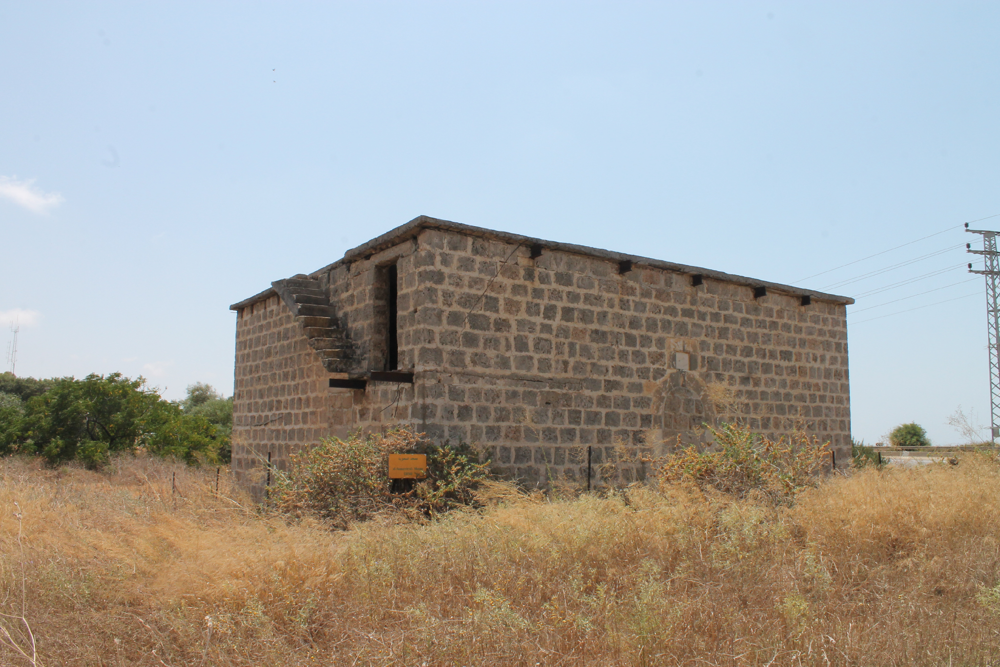
Mosque in as-Sumayriya
مسجد في السُميريه
מסגד הכפר סמרייה
According to the table set near the abandoned building, this small mosque was built in 1936. That means it was active only for 12 years. Now the entrance to the mosque in the north wall is bricked up. The staircase on the east side of the building leads tho the roof where in the south-west corner there are remains of a small square minaret.
Photo of 1948
W. Khalidi visited the former Palestinian village as-Sumayriya in 1987 and described it as follows, “One room from the mosque, portions of a building, segments of walls and arches from fallen houses, and graves are all that remain of al-Sumayriyya. The remaining part of the mosque is a square stone building with a flat roof that is supported on girders and crossbeams. It has a round-arched doorway that is presently closed. Most of the site is covered by a forest of eucalyptus trees interspersed with bushes and wild grass. There is a cowshed on the site's northern section. The lands in the vicinity are cultivated by the settlement of Regba” (1992, 31). The explorer did not mentioned about a small Muslim cemetery located to the south from the mosque and now covered with bushes.
View from the north-east
View from the north-west
There are remains of the Crusader castle to the north from the mosque.
Route. Palestinian village as-Sumayriya was located between kibbutz Lohamei ha-Geta'ot and moshav Regba. The mosque is well observed from Highway 4. You can reach it turning from the Highway to the Shopping centre of moshav Regba.

Visited: 19.08.15
Coordinates: 32°58'18.9"N 35°05'35.6"E
Location of the object on Google Maps
References: Khalidi 1992, 30–31
Mosque in at-Tira
مسجد في الطيرة
מסגד הכפר טירה
Nothing in the exterior of a present synagogue of Tirat Carmel looks loke a former mosque of the Palestinian village at-Tira. The mosque itself was built on the basement of a Byzantine church.


V. Guérin visited in 1870, “I first examined a small mosque, which appears to have been formerly a Christian church. Aligned from west to east it has only a single nave and is terminated towards the east by an apse. One enters through a rectangular door crowned by a fine monolithic lintel. This church, which has been constructed with very regular ashlars, is covered by slightly pointed vaults, above which there is a flat terrace roof” (Samarie II 282).
A. Petersen noted as follows, “A sketch plan of the mosque made in 1932 shows a rectangular prayer hall with a large courtyard to the north. The courtyard had rooms on the west and east sides and was entered through a doorway in the north wall. The entrance to the prayer hall was a door set in an arched recess containing an inscription. The inscription written in provincial naskhi records the construction of the mosque by Ishaq ibn Amir in 687 H. (1288–1289 C.E). The interior of the mosque is divided into six vaulted bays springing from corner piers and resting on two central columns. The columns are capped with reused antique Corinthian capitals” (2001, 306).
Photos in Archive of the Department of Antiquities of Mandatory Palestine (1932)


Route. The centre of former village at-Tira is a city Park Nahal Galim in the present Tirat-Karmel. The former mosque turned into a synagogue is located in the western pat of the park, on ha-Palmach street.

Visited: 18.08.15
Coordinates: 32°45'40.8"N 34°58'28.9"E
Location of the object on Google Maps
amazing...
ReplyDelete