Tomb of nabi Isma‘il
مقام النبي إسماعيل
קבר נבי ישמעאל
The tomb of nabi Isma’il refers to Palestinian village Burin (to the south from Nablus) and was initially called the maqam of sheikh Abu Isma‘il or even Abu Isma‘in. The name kept on to be mentioned in the early 20h century, and the Palestinian map of G. Shumaher.
During the British Mandate sheikh Abu Isma‘in turned into nabi Isma‘il, probably there was an allusion to patriarch Ishmael from the Old Testament. The residents of Burin made such a change in order to attract pilgrims to the tomb, as they got extra revenue from that.
However, the nearest mountain is called Jebel Abu Isma‘il and in modern booklets the tomb is called Abu Isma‘il shrine (title nabi avoided) (Burin Village Profile, p. 6). Thus, it is gradually ganging back to the initial name of the shrine.
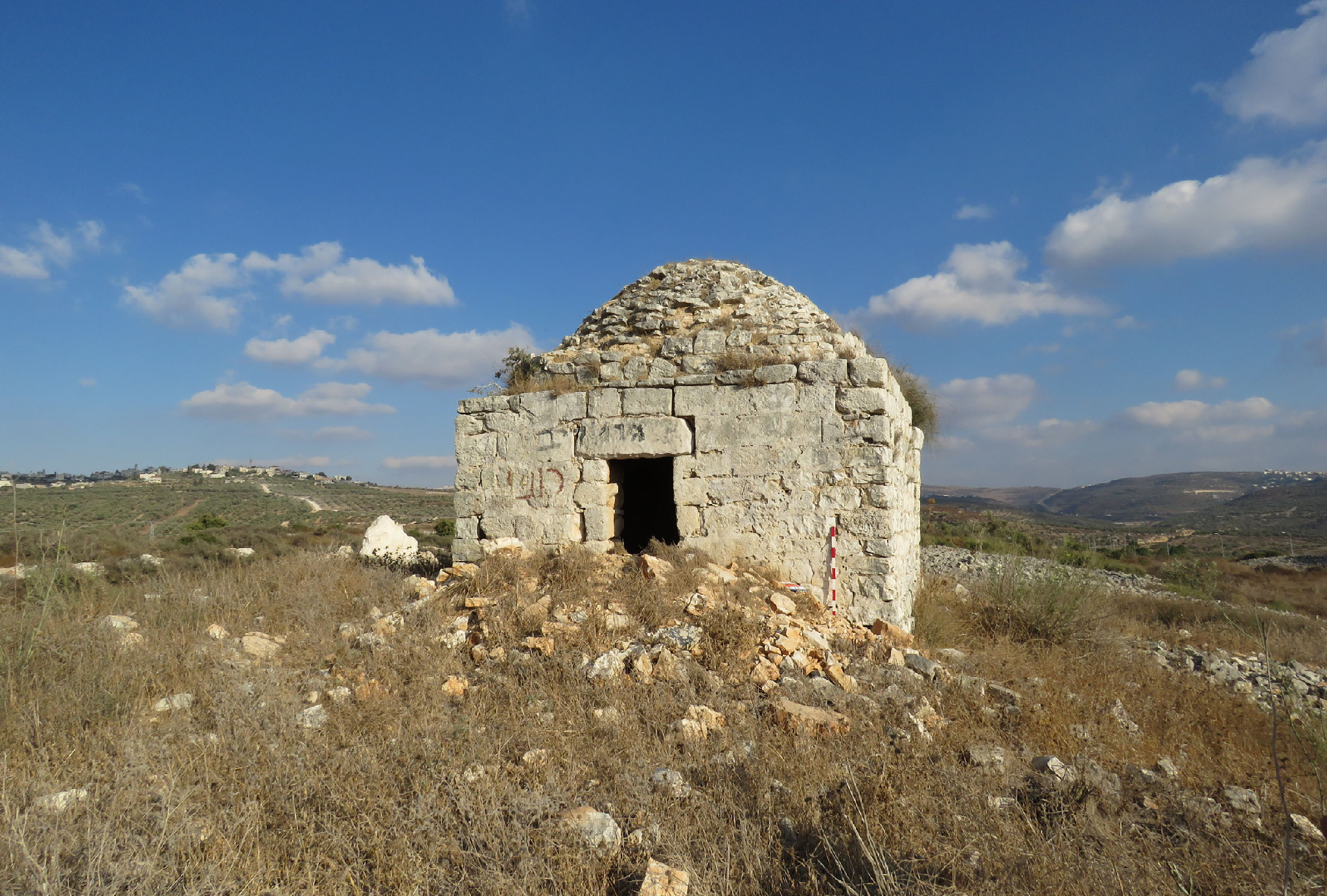
View from the south

View from the west

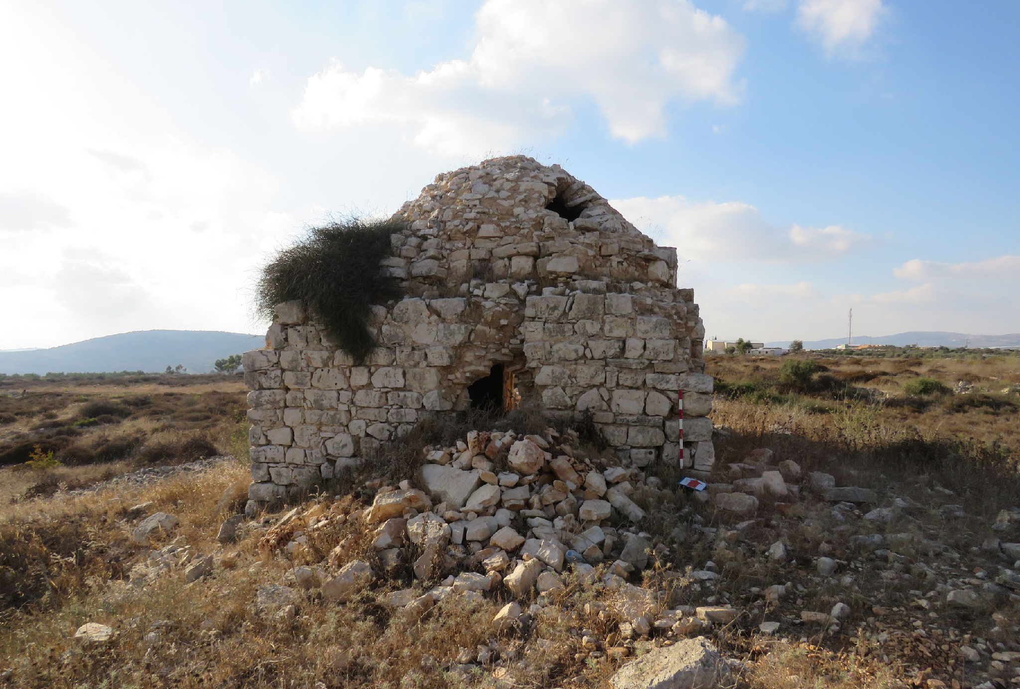
The dome

The structure is quite a prominent building, more than 4 m high, with a dome 1.5 m. The entrance is from the north. The inner plan resembles the tomb of nabi Kifl (see Section 2. Tombs of the Prophets): the same two interconnecting vaulted chambers, separated with an arch. A small mihrab without decorations stands at the south wall in the second chamber. No traces of cenotaph anywhere.
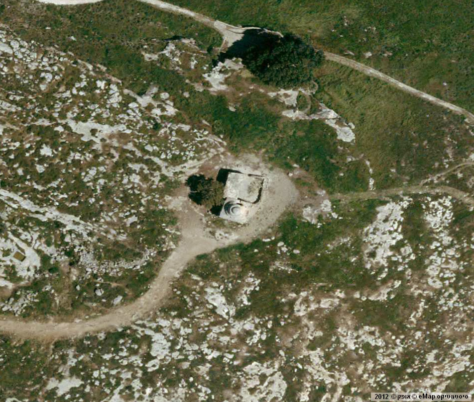
The shrine is surrounded with stone wall with a few entrances. The northern part of the wall forms a small yard in front of the entrance to the tomb. Nearby the tomb to the west there are a few building of different purposes. Some of them are probably hammams (bathhouses). The shrine is located on the edge of the steep slop of the mountain. It used to be observable from the road to Nablus, but now it is hidden in the shadow of trees.
A small yard in front of the entrance to the tomb

Inside the tomb

After, in 1983 Har Brakha, an Israeli
settlement was established as well as an especially advanced outpost Giv'at Sne Ya'akov on Jebel Abu Isma‘il, the residents of Burin lost control over their shrine. The Jewish among the Israeli people perceived that tomb’s name as a reference to Ishmael from the Old Testament, who was the ancestor of Arabs and made a Hebrew inscription on the tomb’s wall: “Eretz Israel (The Land of Israel) is for nation Israel (Jewish), and not for Isma’il (Arabs)”.

The Jewish set a few wooden tables and benches and made somewhat like a rest area on the lawn nearby.
Route. At the checkpoint of Huwwara turn to the road leading to Israei settlement Har Brakha. In 1.3 km at the crossroad turn left and follow a track road 300 m up the tomb.

Visited: 07.08.18
Coordinates: 32°10'37.7"N 35°16'06.6"E
Location of the object on Google Maps
Maqam imam ‘Ali (Qusin)
مقام الإمام علي
מקאם אימאם עלי
One more dilapidated Muslim shrine is in Samaria, nearby Israeli settlement Kdumim, on the territory of the Industrial zone of this settlement.
It is the fifth Palestinian maqam of imam ‘Ali, which used to belong to Arabic village Qusin. The European explorers of the 19th century knew this shrine and marked it on the PEF map of 1879 (Sheet XI).
When the maqam turned to be on the Israeli Industrial zone, it became difficult for Plestinian Arabs to visit it.
When the maqam turned to be on the Israeli Industrial zone, it became difficult for Plestinian Arabs to visit it.
The structure is 5.22 x 5.08 m and consists of a domed burial chamber with the entrance on the north side. There is a mihrab in the south wall and a small niche (taqah) for a lighter in the west wall. The interior of the maqam is very simple: there is no vaulted arches or decorations. Though the brickwork witnesses that a building is quite ancient. It can be dated to the Ottoman period.
View from the north
View from the south
View from the south-west

On the west wall a big Star of David drawn by the Jewish settlers. There are quite a few Hebrew inscriptions both inside the and outside. There are also some old Arabic inscriptions.
A slow destruction of the shrine is going on: the wall with the mihrab has partly collapsed, a big hole has appeared in the dome, the west wall has cracked outside.
Now the floor in the domed chamber is dug up: obviously it was treasure seekers. The dug soil is heaped before the entrance to maqam, and it's challenging to come in. It the remains of a buried saint were kept under the cenotaph, they are also thrown away by the diggers.
The floor in the domed chamber is dug up

On the west wall a big Star of David drawn by the Jewish settlers

The mihrab


Route. There are neither signs nor paths leading to the maqam. You can reach it from the Industrial zone or from Highway 60 by following 400 m among the bushes and sharp stones.
Visited: 07.08.18
Coordinates: 32°14'35.2"N 35°10'08.0"E
Location of the object on Google Maps
References: Palmer 1881, 182 (Sheet XI); Stewardson 1888, 96
Maqam sheikh ‘Abdallah (Beit ‘El)
مقام الشيخ عبد الله
קבר שייח' עבדאללה
The maqam of sheikh ‘Abdallah stands on the territory under control of the Israeli people (Beit El settlement), and that's why it is an abandoned Muslim shrine.
The Domed chamber (5.40 x 4.80 x 2.80 m) borders with an Iwan-like room, walls of which are decorated with arched curves (6.80 x 7.40 m). The entrance to this room is through an open arched doorway in the east wall. A cenotaph stands in the middle of this room. At the same time there is a mihrab in the Domed chamber, but no cenotaph. Due to this fact the Domed chamber is also a Prayer room (though it is not clear whether it was originally a Prayer room). A doorway to this room is restored and decorated with tree and dot ornaments. The same red pictures decorate the mihrab in the south wall.
View from the east
%20air1.jpg)
View from the south-west
%20air2.jpg)
View from the south-east

View from the south

View from the west

The Domed chamber

Iwan-like room

Iwan-like room

Entrance to the Domed chamber

Mihrab in the Domed chamber

Cenotaph in the Iwan-like room

Recently the Jewish have set a tradition to worship this land. It is called Khalom Ya'akov (“The dream of Jacob”) or Pigsat Ya’akov (פסגת יעקב) (‘The height of Jacob). It was worshipped as a place where biblical patriarch Jacob saw his prophet dream (Gen. 28:10–22). The video of Hgi Ben-Artzi shows how sheikh ‘Abdallah is identified as biblical Jacob, and the maqam is a place of his prophet dream. At the same time the Domed chamber is considered as an early Muslim building, and an adjacent structure – as a orthodox chapel built in the times of Crusaders.
A Russian video.
A Russian video.
We did not find in the maqam anything related to crusaders. It is a typical Muslim tomb, built in the Ottoman period. Its construction is very similar to the maqam of sheikh Ahmad al-Hubani in the Judaean Mountains and sheikh Muhammad al-Musli in al-Jura (see Chapters 3, 5). The fact that Jewish tombs of period of the Second Temple were in the area along with the traces of an ancient settlement proves that this place was habitable very long ago.
Our video about the maqam
An overall condition of the monument isn't satisfying. A part of the west wall of the big chamber collapsed, the destruction of the dome in the burial chamber also started.
A holy oak tree grows near the maqam, and its dependent branches are carefully supported with metal buttresses, the tree itself is surrounded with a fence. It's obvious that the tree is treated much better than the Muslim shrine.
A holy oak


Route. The maqam can be reached through Israeli settlement Beit El (northerneast direction) or through Ha-Mesila street up to Khalom Ya'akov. There is a parking with a small monument. The maqam is behind this parking.
Visited: 14.08.15
Coordinates: 31°56'58.5"N 35°13'55.3"E
Location of the object on Google Maps
Maqam sheikh Abu Isma‘il
مقام الشيخ أبو إسماعيل
קבר שייח' אבו ישמעאל
It is a domed structure which is located on the rock hill a bit to the north from Palestinian village Budrus (from Greeck “Petros”). On the PEF map it is marked as the Tomb of sheikh ‘Obeid Rahil (Sheet XIV, Jr). The name sheikh Abu Isma‘il appeared on the maps during the British Mandate. C. Conder commented on the two places near Budrus, “two sacred places, and a graveyard near one (imam ‘Aly) on the west” (SWP II 296). In fact, the tomb of imam ‘Aly is still surrounded with the cemetery. The second shrine mentioned by C. Conder is the tomb of sheikh ‘Obeid Rahil (Abu Isma‘il).
By present time only parts of western and southern walls and a piece of a collapsed dome have been saved. In the bottom of the walls there are huge blocks and stones, with smaller stones above them. The original size of the building is 4.10 x 3.80 x 2.20 m. The entrance to maqam was in the north wall, which now is totally destroyed. Along two sides of the rounded mihrab at the south wall there are square holes for candles or lamps. Among the wreckages, it is impossible to identify whether there was a cenotaph inside and where exactly it stood.
View from the south

View from the west

View from the north

This high hill with the remains of the maqam on the top is a very prominent and didactic place. This is the place where a sharp contrast between the blooming and well treated tomb of imam ‘Ali and abandoned, destroyed by there fourths tomb of sheikh Abu Isma‘il strikes the eye. Unfortunately, the tomb of sheikh Abu Isma‘il happened to be on the Israeli territory, in front of the Separation barrier. The two shrines are facing each other at a 1.5 km distance.
Maqam of imam ‘Ali in Budrus

Maqam of imam ‘Ali in Budrus

It's worth mentioning that the residents of Budrus arranged demonstrations against the construction of the Separation barrier, called it “The Apartheid Wall”. A documentary “Budrus” was filmed about that in 2009.
Route. You can reach the object via an asphalt road which starts at the Industrial zone of Shoham, goes under Highway 6 and leads to the south for almost 3 km and after the crossroad near Tel Dalit (opposite moshav Beit Nehemia) goes 3 km to the east. The road before Palestinian Budrus is blocked with stones, but we managed to pass it, though with some difficulties.
The landscape around it looks like footage from “Stalker” by A. Tarkovsky: there are lots of targets, people and house dummies, damaged hardware. The matter is that the Israeli troops use this territory as a firing area, so you can easily pass this site only on Saturdays (Shabbat). What's more, an iron shield with bullet traces is laying just on the maqam.

Visited: 15.08.15
Coordinates: 31°58'33.5"N 34°59'14.5"E
Location of the object on Google Maps
Maqam sheikh Bilal
مقام الشيخ بلال
קבר שייח' בלאל
Bilal ibn Rabah was the first dark-skinned slave in Mecca who converted to Islam and became one of the supporters (ashabs) of Muhammad the Prophet and the first muezzin. In 638 he took part in the crusade of caliph Umar to Syria and Palestine. Bilal died in 640 or 642 and was buried either in Medina or in Damascus. There is still his tomb at the cemetery Bab as-Saghir in Damascus.
In Samaria there is also the maqam of Bilal built on the top of Kabir Mountain, which dominates over Nablus valley as well as over al-Fari‘a valley. E. Robinson was the first who noticed this shrine, “the Wely Neby Belan, conspicuously situated on the mountain east of the valley which descends from the Mukhna to Wady Fari‘a” (1856, 298). V. Guérin described a significant and unusual steepness Djebel Neby Belan, though he did not mention the maqam itself (Samarie I, 370). C. Conder explained, “Nebу Вelan is identified by the natives with Bilal ibn Rubah, the Muedhen of the Prophet” (SWP II, 249).
It is rational to suppose that first it was a local holy man called nabi Belan or Bilan, but later he was identified with a famous hero of Muslim legends called Bilal ibn Rabah due to the similarity of the names. Consequently, the local holy man was downgraded from the “prophet” to “sheikh”.
The maqam of sheikh Bilal outstands among other Palestinian shrines due to its unusual three-stepped dome above the burial chamber. A two-arched Iwan and a small walled yard border with it from the north. Nearby on the west there grows a holy tree – kermes oak.
The maqam of sheikh Bilal outstands among other Palestinian shrines due to its unusual three-stepped dome above the burial chamber. A two-arched Iwan and a small walled yard border with it from the north. Nearby on the west there grows a holy tree – kermes oak.
View from the east

Photo of 2010

View from the south-west

View from the north

A two-arched Iwan

The mihrab

In 1980, after Israeli settlement Elon-Moreh was established on Kabir Mountain, the Palestinian Arabs (the residents of village Azmut, on the territory of which the maqam was located) lost control over their shrine. The settlers of Elon-Moreh included the maqam of sheikh Bilal into their lands. Though the maqam wasn't subject to judaisation or radical reconstruction, from time to time there were some construction works. In 2018 the Israeli residents started large-scale works to make a park or a rest zone around the Muslim shrine. When we were visiting the maqam, excavating works were proceeding nearby. The shrine itself is walled with metal fence with no entrance.
Israeli settlement Elon-More and Kabir Mountain


Route. You can reach the maqam only through settlement Elon-Moreh following the street signs “Kabir Mountain”. A track road leads from the settlement up to the top of the mountain.
Visited: 07.08.2018
Coordinates: 32°14'32.8"N 35°19'40.9"E
Location of the object on Google Maps
References: Robinson 1856, 298; 301; Guérin, Samarie I, 370, 458; SWP II 249; Palmer 1881, 205 (Sheet XII); Stewardson 1888, 131
Addition: Panorama
Maqam sheikh ‘Isa
مقام الشيخ عيسى
קבר שייח' עיסא
Following the road up to Israeli settlement Harasha you can meet a small hill topped with the tomb of sheikh ‘Isa. Now this place is called Winery Hill (Hebrew: Giv'at Yekevim). There goes a tourist path with red marks.
On the PEF maps the shrine is called sheikh ‘Aisa (Sheet XIV). C. Conder who visited these places in 1873, described as follows, “Batn Harasheh — The ruins here are merely foundations near sheikh ‘Aisa. There is also a cave with a central column of rock” (SWP II 303).According to him, the shrine was surrounded with ruins, though itself it wasn't destroyed.
View from the north-west

Maqam on the British map 1918

Now the maqam (5.40 x 4.40 x 1.50 m) is half ruined. The dome collapsed, the south wall is badly damaged. The north wall survived much better with an entrance doorway 1.20 m high. Those who came in should bend thereby bowing respectfully to the buried holy man. A low, 1 m high rounded mihrab in the south wall, and a pair of square holes in the side walls made for lamps – these are all the interior details. No trace is left from a cenotaph.
To the right from the maqam's entrance in the north wall there is a small annex with a hole in the centre, like a washbasin. This peculiar detail is unusual for Palestinian maqams.
View from the north

Mihrab in the south wall

To the right from the maqam's entrance in the north wall there is a small annex with a hole in the centre

Route. You should turn from Highway 450 to the asphalt road leading to settlement Harasha, and in 800 m you reach the maqam.
Visited: 16.08.15
Coordinates: 31°56'39.0"N 35°08'36.0"E
Location of the object on Google Maps
Maqam sheikh Salman al-Farsi
مقام الشيخ سلمان الفارسي
קבר שייח' סלמאן הפרסי
Salman al-Farsi (i.g. Pesian) was one of the companions (ashabs) of Muhammad the Prophet. He took part in Arabic captures of Palestine, Syria and Iraq. According to one legends, he was buried in Iraqi Madain, according to others – in Isfahan. However, in Palestine there are a few maqams named Salman al-Farsi.
One of them belongs to Palestinian village ‘Asira al-Qibliya. It stands on the top of Djebel Salman mountain. In 1983, when an Israeli settlement Yitzhar was established on this mountain, the maqam turned to be on its territory, and the residents of Asira lost control over their shrine.
The maqam is 5.75 x 5.20 m and consists of a domed chamber, with the entrance in the north wall and arched window in the east wall. Outside of the west wall there are some steps leading the top leading to the roof top. A mihrab standing the in south wall is rounded and without any decorations. There is no trace of a cenotaph there.


According to the brickwork, this structure can be dated to the first half of the 19th century. The wely of sheikh Salmon el-Farisy is mentioned by E. Robinson, who saw him in 1852 (1856, 296). On the PEF map (Sheet XI) and in the list of the Palestinian objects of E. Palmer (1881, 191), this sheikh is called Selman el-Farsi.
It's interesting that there is a burial cave under the maqam which one can get into only creeping through a low and narrow creephole.


The residents of Yitzhar are doing their best to save the Muslim sanctuary and its surroundings as a local landmark.

Visited: 07.08.18
Addition: PanoramaOne of them belongs to Palestinian village ‘Asira al-Qibliya. It stands on the top of Djebel Salman mountain. In 1983, when an Israeli settlement Yitzhar was established on this mountain, the maqam turned to be on its territory, and the residents of Asira lost control over their shrine.
The maqam is 5.75 x 5.20 m and consists of a domed chamber, with the entrance in the north wall and arched window in the east wall. Outside of the west wall there are some steps leading the top leading to the roof top. A mihrab standing the in south wall is rounded and without any decorations. There is no trace of a cenotaph there.
View from the north

View from the north-east

View from the north-west
View from the south-east

According to the brickwork, this structure can be dated to the first half of the 19th century. The wely of sheikh Salmon el-Farisy is mentioned by E. Robinson, who saw him in 1852 (1856, 296). On the PEF map (Sheet XI) and in the list of the Palestinian objects of E. Palmer (1881, 191), this sheikh is called Selman el-Farsi.
It's interesting that there is a burial cave under the maqam which one can get into only creeping through a low and narrow creephole.
A burial cave under the maqam

Arched window in the east wall

The mihrab

The residents of Yitzhar are doing their best to save the Muslim sanctuary and its surroundings as a local landmark.

Visited: 07.08.18
Coordinates: 32°10'07.3"N 35°13'58.1"E
Location of the object on Google Maps
Qubbat an-Najma
قبة النجمة
קובת א-נג'מה
On the top of the Mountain which dominates over the territory from Bethel to the Jordan Valley there stands one of the oldest Palestinian shrines — Qubbat an-Najma. There are a few versions about the origin of this name and the name of the person buried in the tomb. One people think that Arabic Qubbat an-Najma – “the dome of a morning star” — is a poetic name given to the shrine. Others believe that a Muslim sheikha Sitt Zuhra is buried there, as she was worshipped in the settlement at the foot of the mountain.
However, V. Guérin who visited these places in 1863, commented as follows, “At 05:30 I saw wely Neby Nedjemeh to the east across the deep ravine on the neighboring mountain” (Samarie I, 213–214). It is the earliest mentioning of this shrine. We can suppose that guides told to the French traveler that a prophet called Nadjma or Nedjemeh had been buried there.
Though it is strange that V. Guérin did not mention the name of this prophet, but only gave him a nickname-nisba (Arabs do not have name Nedjemeh). The question is how much accurate the French traveler is. Maybe “Prophet Nedjemeh” is his own interpretation of the traditional name Qubbat an-Najma”? Thus V. Guérin invented this prophet.
Photo of 1990s

Photo of 2012

When Israeli settlement Kokhav ha-Shakhar (its name duplicates Arabic an-Nadjma) and a few Jewish advanced outposts were established in 1979, the Arabic settlement was pushed away from this territory and lost control over the shrine on the top of the mountain. It was left unattended. In the early 2000 the structure was quite undamaged, and the photos prove that. But after it rapidly collapsed. The Israeli say it ruined because of wind exposure.
In the past Qubbat an-Najma had an ideal square from (5.0 x 5.0 m). Like in other Palestinian shrines the entrance to the maqam was in the north wall. The building was walled with a square stone fence, set 2 m away from the shrine.
View from the south

View from the north

The mihrab in the south wall

View from the south-west

Now there is only the lower blockwork 1–1,5 m high and the remains of a small mihrab. The maqam inside is blocked up with wreckage of the collapsed dome. Qubbat an-Najma is destroyed as much as the maqam of sheikh ‘Abd al-Aziz nearby Mevaseret Zion (see Section 3. Maqams. Judaean Mountains).


Route. Turn from Highway 458 to the road leading to Kokhav ha-Shakhar. Before the settlement turn right to the track road up to the mountain. This road is fine only for jeeps. A bit better road goes round the mountain from the south and climbes up to a viewing point on the steep eastern slope. We could reach it by an ordinary car till this point, and went further on foot.
Visited: 14.08.15
Coordinates: 31°56'54.6"N 35°21'06.8"E
Location of the object on Google Maps
References: Robinson 1856, 292; Guérin, Samarie I, 213–214; Palmer 1881, 256 (Sheet XV); Stewardson 1888, 122; Ariel 1996, 111; Wikipedia: Qubbat an-Najma; iNature Rimonim – Kokhav ha-Shakhar;
No comments:
Post a Comment